Home

TTR News Center

TTR Weather Update including information for Goliad and Victoria Counties, Victoria Crossroads Area, and Coastal Bend from NWS Corpus Christi

No Comments Local News

…Freeze WATCH and Wind Chill Advisory for ALL of South Texas Tonight/Saturday Morning…

No Winter Precipitation is Expected…

Briefing:

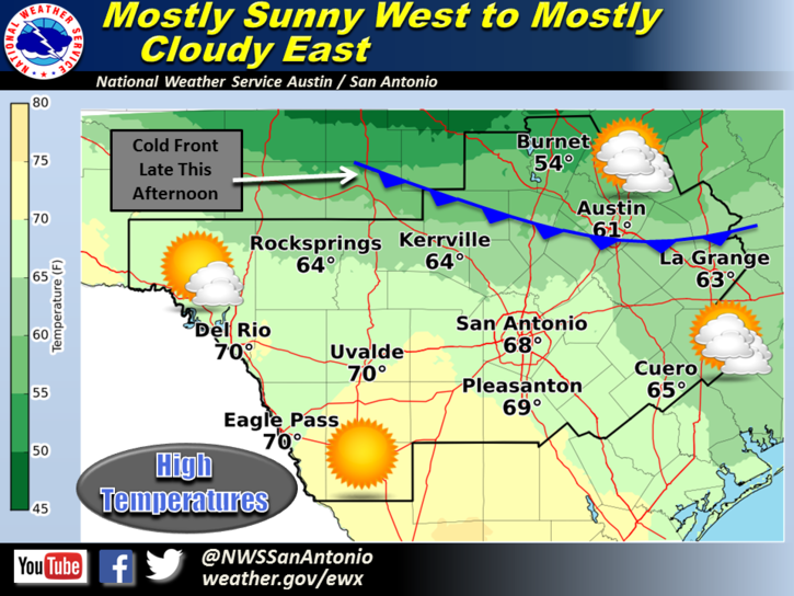
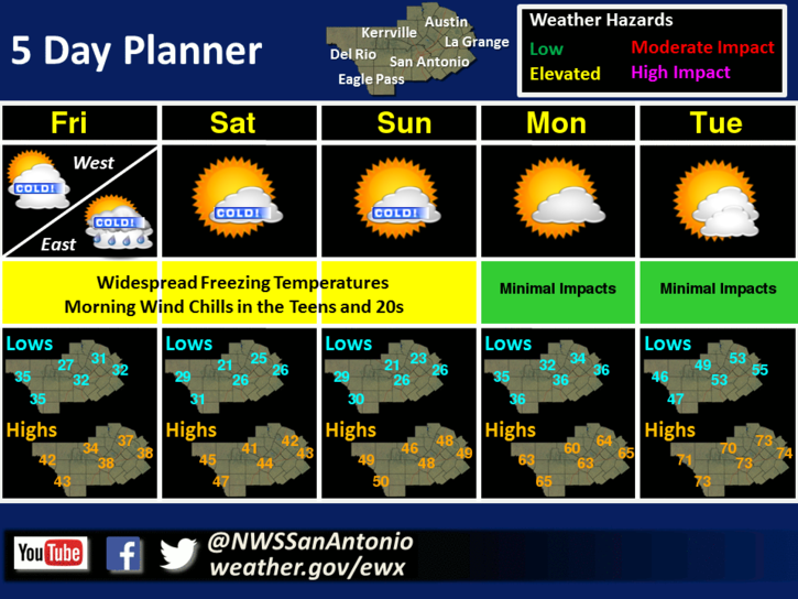
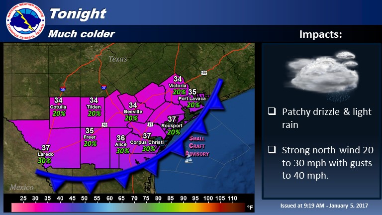
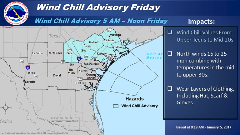
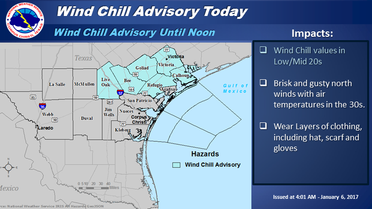
Cold conditions will prevail today across South Texas. Temperatures will fall into the 30s this morning and likely fail to reach 40 degrees during the day. The cold temperatures, along with brisk and gusty north winds, will result in wind chill values this morning lowering to 20 to 25 degrees across the Northern Coastal Bend. Elsewhere, wind chills will likely lower into the upper 20s to around 30 degrees…with only minor improvement occurring this afternoon.

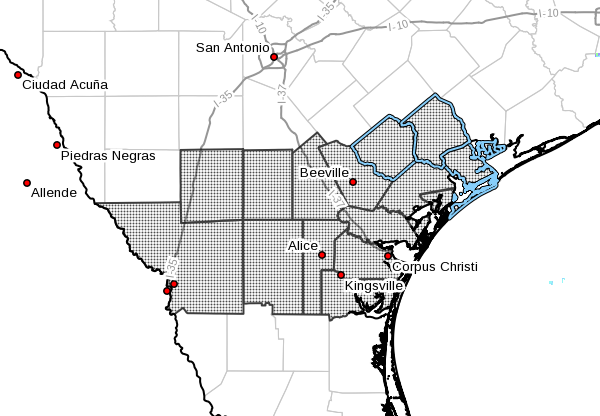
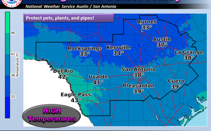
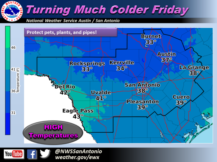
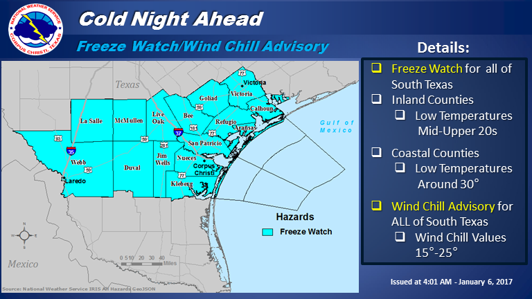
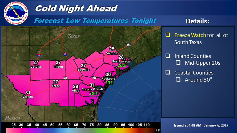
Cold conditions are expected tonight. A Wind Chill Advisory is in effect for all of South Texas tonight into Saturday morning with minimum wind chill values of 15 to 25 degrees expected. A Freeze Watch is also in effect for of South Texas tonight and Saturday morning. Temperatures are expected to fall into the mid to upper 20s across inland counties (around 30 degrees for Laredo). The coastal counties can expect a brief light freeze around 30 degrees to the lower 30s (warmest along the coast).

Areas of light rain and drizzle may occur today, especially this morning. At this time, no wintry precipitation of significance is expected today. However, an isolated sleet/ice pellet may occur across the area, but impacts should be nil.

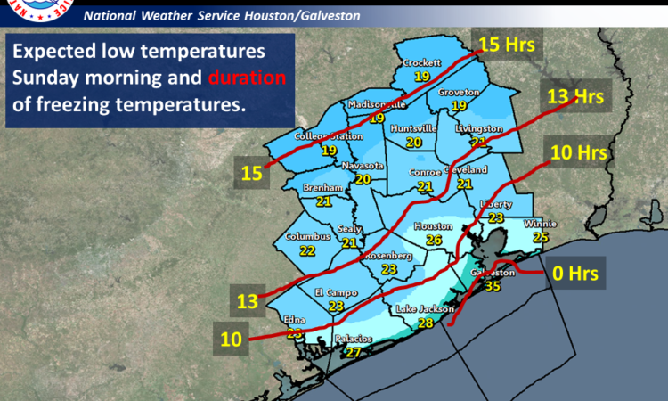
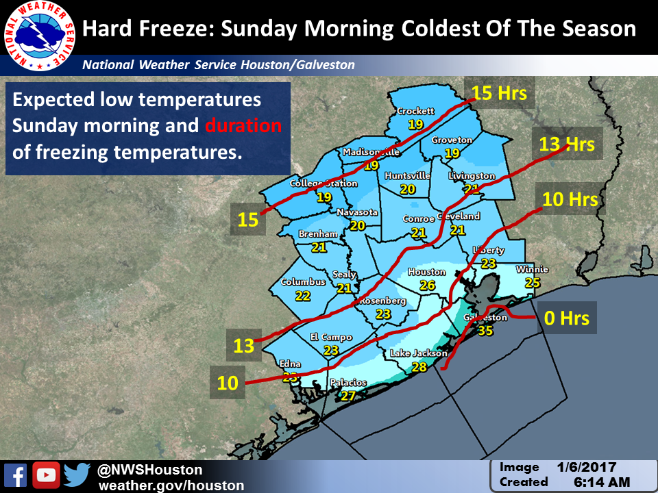
An additional round of freezing temperatures are expected for inland areas Saturday Night into Sunday Morning.

Small Craft Advisories continue for all marine areas. Marine wind speeds may temporarily decrease in intensity this afternoon, but quickly restrengthen this evening to levels slightly stronger than what were experienced early this morning. A few gusts to gale force may occur tonight across marine areas.South Texas Impacts:

  • Wind Chills:
    • Values lowering to 20 to 25 degrees this morning across the Northern Coastal Bend.
    • Values in the upper 20s to around 30 degrees elsewhere.
    • Only minor improvement expected this afternoon.
    • Values lowering to 15 to 25 degrees tonight into Saturday morning.
  • Freezing Temperatures:
    • Freeze Watch for all of South Texas tonight into Saturday morning.
    • Lows mid to upper 20s across inland counties (around 30 degrees for Laredo).
  • Lows around 30 degrees across coastal counties (around 32 along the coast).
  • Wintry Precip:
    • Likely none.
    • One or two ice pellets mixed in with light rain and drizzle.
    • No wintry precip impacts are expected at this time.
  • Marine Conditions:
    • North winds around 25 knots, gradually weakening some this afternoon.
    • Restrengthening wind speeds tonight to 25 to 30 knots.
    •  Few gusts to gale force possible tonight.
    • Bays rough to occasionally very rough, especially this evening and overnight.
    • Seas 7 to 10 feet with locally higher seas possible

4
5
6

Additional Information Resources:

NWS Corpus Christi Webpage: www.weather.gov/crp/

Sincerely,

Rob Hart
Forecaster
NWS Corpus Christi, TX

TTR Weather Update including information for Colorado, Jackson, and Wharton Counties from NWS Houston/Galveston

No Comments Local News

Hope you got your coats handy. Very cold air will be pouring into the region on stiff north winds today and tonight. Some patchy light rain will be possible across the areas south of a Bellville to Huntsville line and a few flakes of snow or sleet may be possible there.

Precipitation: Patchy light freezing drizzle or ice pellets may fall north of that line this morning but the ground is warm and is unlikely to cause any issues. The exception being any elevated roads or bridges along and north of a line from Caldwell to College Station to Groveton where patchy ice may be possible.

Wind and wind chills will be problem today through Saturday morning.

1

2
Saturday night and Sunday morning will be the coldest of the season with a long period of below freezing temperatures and hard freeze may be possible as far south as the Highway 59 corridor including the northern half of Harris county.

3

Wind: Wind advisory in effect across Wharton and the immediate coastal counties today with winds of 20 to 30 mph and gusty through 6 am Saturday.
Over the bays and coastal waters 20 to 30 knots of north winds with higher gusts. Small craft advisories are in effect. A gale watch is up for the waters beyond 20 nautical miles for tonight where wind gusts around 35 knots will be possible.

Kent Prochazka/Melissa Huffman
National Weather Service Houston/Galveston

Special Weather Statement for Calhoun, TX, Goliad, TX, Victoria, TX

No Comments Local News

…Freezing temperatures possible Saturday morning and likely
Sunday morning over inland portions of South Texas…

img_0477

A cold arctic airmass will begin to overspread South Texas
tonight behind a strong cold front. Gusty northerly winds will
continue through Friday night pushing even colder air in and
allowing temperatures to drop to near freezing over some inland
sections…especially over the Northern Brush Country, Northern
Coastal Bend and Victoria Crossroads area. A freeze warning will
likely be needed by Friday afternoon for portions of South Texas.

On Saturday night winds will weaken slightly and with mostly
clear skies even colder conditions are expected. Nearly all of
South Texas away from the coast will see a freeze, with lows the
mid 20s northern areas to upper 20s and lower 30s southern areas.
Areas near the coast will see lows in the mid 30s Sunday morning.
Another freeze warning will likely be needed for Saturday night
and Sunday morning.

Residents in South Texas are strongly urged to stay tuned to NOAA
weather radio…commercial radio…television…or other forms of
communication for information regarding this upcoming cold weather
event from your National Weather Service Weather Forecast Office
in Corpus Christi Texas.

Much colder temperatures can be expected across all of south central Texas beginning Friday and continuing through the upcoming weekend.

No Comments Local News

image1
Skies will range from mostly sunny along the Rio Grande to mostly cloudy across the coastal plains today. Temperatures will be warmer compared to yesterday. However, a cold front will move into the region late this afternoon bringing increasing north winds and cooler air to the region. Highs will range from near 70 along the Rio Grande to the mid 50s in the northern Hill Country.

image3
Much colder temperatures can be expected across all of south central Texas beginning Friday and continuing through the upcoming weekend. High temperatures on Friday will remain in the 30s for most areas, except for near 40 along the Rio Grande. A freeze is expected across all areas Friday night and again Saturday night. The coldest temperatures are expected across the Hill Country where a hard freeze is in store with overnight lows near 20 degrees both nights. Wind chills will be in the teens and twenties for most areas Friday, Saturday and Sunday mornings.

image4
Much colder temperatures are in store for the end of the work week through the upcoming weekend across south central Texas. Widespread freezes are in store along with morning wind chills in the teens and 20s Friday through Sunday. There is a slight chance of light rain across the coastal plains and Highway 77 corridor on Friday, but temperatures are currently expected to be above freezing during this period of possible precipitation. A warming trend is expected for early next week.

Now, here’s your Texas Thunder Radio Weather from the National Weather Service in Austin/San Antonio:

Tonight:
Colder. Mostly cloudy. Lows in the mid 30s. North winds 15 to 20 mph with gusts to around 30 mph.

Friday: Much colder. Cloudy with a 20 percent chance of rain. Highs in the upper 30s. North winds 15 to 20 mph.

Friday Night: Mostly cloudy before midnight then becoming partly cloudy. Lows in the upper 20s. North winds 10 to 15 mph with gusts to around 25 mph. Wind chill readings 20 to 25.

Saturday: Partly cloudy in the morning then becoming sunny. Highs in the lower 40s. North winds 10 to 15 mph. Lowest wind chill readings 20 to 25 in the morning.

Saturday Night And Sunday: Clear. Lows in the upper 20s. Highs around 50. Wind chill readings 30 to 35.

Sunday Night And Monday: Warmer. Partly cloudy. Lows in the upper 30s. Highs in the upper 60s.

***For local weather information, visit the TTR Weather Center, powered by NWS Austin-San Antonio.

***For Road Condition Information, visit the TTR Traffic Center, powered by DriveTexas.org.

Stay Warm,
Texas Thunder Radio

TTR Weather Update from NWS Corpus Christi including information for Goliad and Victoria Counties

No Comments Local News

…Wind Chill Advisory for Northern Coastal Bend Tonight through Friday Morning…

No Winter Precipitation is Expected…

tonight
A strong cold front will move through South Texas early this evening ushering in a very cold air mass which will persist into the weekend.  Temperatures will drop into to mid to upper 30s across most of South Texas overnight with gusty north winds and wind chill values in the 20s.  A Wind Chill Advisory has been issued for the Northern Coastal Bend for Tonight through Friday Morning, and this may need to be expanded farther south to include the entire Coastal Bend. Small craft advisory conditions are expected over all marine areas where wind gusts to gale force will be possible.  High temperatures on Friday will hold steady in the upper 30s to around 40 degrees with patchy light rain and drizzle. Atmospheric temperatures will not be cold enough for winter precipitation. Temperatures will remain chilly through the weekend with highs Saturday in the mid-upper 40s and highs Sunday in the mid to upper 50s.

South Texas Impacts:

chill

Wind Chills: Wind chill values will range from the upper teens to lower 20s across the northern Brush Country and Victoria Crossroads area late tonight through Friday morning.  Wind Chills in the mid to upper 20s can be expected across the southern Coastal Bend and Coastal areas.  To stay warm, wear several layers of clothing, including hat, scarf and gloves.

Wind Speeds:  Strongest winds will be observed along the Coast where North winds of 20 to 30 mph with gusts 35 to 40 mph will be possible Tonight through Friday.

Marine Conditions:  North winds increasing to 25 to 30 knots after midnight Tonight and persisting through Friday. Gusts to gale force possible.  Bays will be Choppy to Rough.  Seas building to 6 to 8 feet offshore with occasional seas up to 10 feet.  Winds and seas gradually diminishing on Saturday. Small Craft Advisories are in effect for Tonight through Friday Night.

Additional Information Resources:
NWS Corpus Christi Webpage: www.weather.gov/crp/

Sincerely,
John
NWS Corpus Christi, TX