…HURRICANE WATCH IN EFFECT…
A Hurricane Watch means Hurricane wind conditions are possible
somewhere within this area and within the next 48 hours
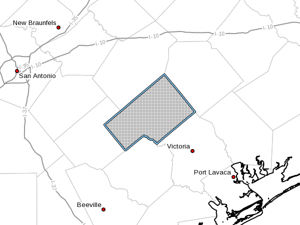
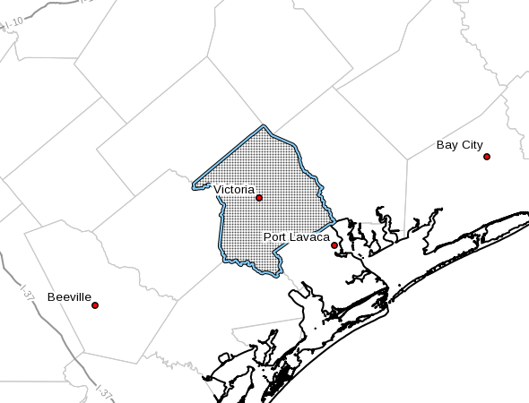
- LOCATIONS AFFECTED
- Victoria
-
Bloomington
-
WIND
- LATEST LOCAL FORECAST: Equivalent Tropical Storm force wind
- Peak Wind Forecast: 35-45 mph with gusts to 60 mph
-
Window for Tropical Storm force winds: early Friday morning
until early Sunday morning -
CURRENT THREAT TO LIFE AND PROPERTY: Moderate
- Emergency planning should include a reasonable threat for
strong tropical storm force wind of 58 to 73 mph. - To be safe, earnestly prepare for the potential of
significant wind impacts. Efforts should now be underway to
secure all properties. -
Dangerous wind is possible. Failure to adequately shelter
may result in injury. -
POTENTIAL IMPACTS: Significant
- Some damage to roofing and siding materials, along with
damage to porches, awnings, carports, and sheds. A few
buildings experiencing window, door, and garage door
failures. Mobile homes damaged, especially if unanchored.
Unsecured lightweight objects become dangerous projectiles. - Several large trees snapped or uprooted, but with greater
numbers in places where trees are shallow rooted. Several
fences and roadway signs blown over. - Some roads impassable from large debris, and more within
urban or heavily wooded places. A few bridges, causeways,
and access routes impassable. -
Scattered power and communications outages, but more
prevalent in areas with above ground lines. -
FLOODING RAIN
- LATEST LOCAL FORECAST:
-
Peak Rainfall Amounts: 6-10 inches, with locally higher
amounts -
CURRENT THREAT TO LIFE AND PROPERTY: Elevated
- Emergency planning should include a reasonable threat for
minor flooding where peak rainfall totals are near amounts
conducive for localized flash flooding and rapid inundation. - To be safe, prepare for the potential of limited flooding
rain impacts. -
Localized flooding is possible. If flood related watches
and warnings are issued, heed recommended actions. -
POTENTIAL IMPACTS: Limited
- Localized rainfall flooding may prompt a few evacuations.
- Rivers and tributaries may quickly rise with swifter
currents. Small streams, creeks, canals, and ditches may
become swollen and overflow in spots. -
Flood waters can enter a few structures, especially in
usually vulnerable spots. A few places where rapid ponding
of water occurs at underpasses, low-lying spots, and poor
drainage areas. Several storm drains and retention ponds
become near-full and begin to overflow. Some brief road and
bridge closures. -
TORNADO
- LATEST LOCAL FORECAST:
-
Situation is unfavorable for tornadoes
-
CURRENT THREAT TO LIFE AND PROPERTY: None
- Emergency planning need not include a threat for tornadoes.
Showers and thunderstorms with strong gusty winds may still
occur. - Little to no preparations needed to guard against tropical
tornadoes. -
Ensure readiness for the next tropical tornado event.
-
POTENTIAL IMPACTS: Little to None
-
Little to no potential impacts from tornadoes.
-
FOR MORE INFORMATION:
- https://www.weather.gov/srh/tropical?office=crp