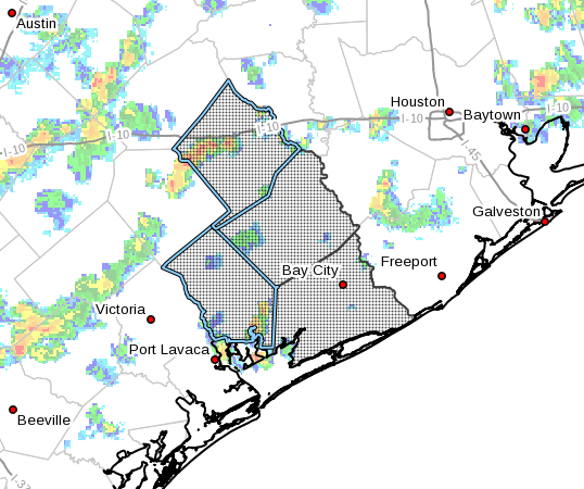
Hurricane Harvey Local Statement Advisory Number 18
National Weather Service Austin/San Antonio TX AL092017
431 PM CDT Thu Aug 24 2017
This product covers SOUTH CENTRAL TEXAS
Hurricane Harvey expected to bring a life-threatening heavy rainfall
event across South Central Texas
NEW INFORMATION
CHANGES TO WATCHES AND WARNINGS:
None
CURRENT WATCHES AND WARNINGS:
A Tropical Storm Warning is in effect for Atascosa, Bastrop,
Bexar, Caldwell, Fayette, Gonzales, Guadalupe, Lavaca, and
Wilson
A Hurricane Warning is in effect for De Witt and Karnes
STORM INFORMATION:
About 450 miles south-southeast of Austin TX or about 370 miles
southeast of Cuero TX
24.7N 93.9W
Storm Intensity 85 mph
Movement North-northwest or 330 degrees at 10 mph
SITUATION OVERVIEW
Harvey continues to strengthen and is now a Category One Hurricane.
Harvey is still moving slowly northwestward in the Gulf of Mexico. This
northwestward movement is expected to continue and Harvey should
approach the Texas coast late Friday into Saturday. Confidence
continues to increase for tropical storm winds and a significant heavy
rainfall event across South Central Texas beginning Friday afternoon
and continuing through Tuesday. Flash flooding and river flooding
continue to be the main concerns, mainly within the Tropical Storm
Warning and Flash Flood Watch areas.
Hurricane Harvey will produce a life-threatening heavy rainfall event.
Storm total rainfall amounts from Friday through Tuesday could be in
the 10 to 20 inch range along and east of Interstate 35 with isolated
totals in excess of 25 inches possible over areas south of Interstate
10 as Harvey is expected to stall over the area. Devastating mainstem
river flooding is possible east of Interstate 35 and south of
Interstate 10.
Additionally, hurricane force winds of 70 to 80 mph will be possible
for the counties within the Hurricane Warning, while 40 to 50 mph
winds with some gusts to 60 mph will be possible for areas within the
Tropical Storm Warning. The timing of these winds look to arrive Friday
night through Saturday morning. There is a low risk of brief tornadoes
east of Interstate 35 and south of Interstate 10 Friday evening into
the weekend associated with tropical rain bands.
POTENTIAL IMPACTS
FLOODING RAIN:
Protect against life-threatening rainfall flooding having possible
devastating impacts across areas east of Interstate 35 and south of
Interstate 10. Potential impacts include:
Extreme rainfall flooding may prompt numerous evacuations and
rescues.
Rivers and tributaries may overwhelmingly overflow their banks
in many places with deep moving water. Small streams, creeks,
canals, arroyos, and ditches may become raging rivers. In
mountain areas, deadly runoff may rage down valleys while
increasing susceptibility to rockslides and mudslides. Flood
control systems and barriers may become stressed.
Flood waters can enter numerous structures within multiple
communities, some structures becoming uninhabitable or washed
away. Numerous places where flood waters may cover escape
routes. Streets and parking lots become rivers of raging water
with underpasses submerged. Driving conditions become very
dangerous. Numerous road and bridge closures with some weakened
or washed out.
Protect against life-threatening rainfall flooding having possible
limited to extensive impacts across areas along and east of the
Interstate 35 Corridor.
WIND:
Protect against life-threatening wind having possible devastating
impacts across areas in the Tropical Storm and Hurricane Warnings
mainly east of Interstate 35. Potential impacts in this area include:
Structural damage to sturdy buildings, some with complete roof
and wall failures. Complete destruction of mobile homes. Damage
greatly accentuated by large airborne projectiles. Locations
may be uninhabitable for weeks or months.
Numerous large trees snapped or uprooted along with fences and
roadway signs blown over.
Many roads impassable from large debris, and more within urban
or heavily wooded places. Many bridges, causeways, and access
routes impassable.
Widespread power and communications outages.
Also, protect against life-threatening wind having possible limited
to extensive impacts across areas along and east of the Interstate 35
Corridor.
TORNADOES:
Protect against a tornado event having possible limited impacts across
areas within the Tropical Storm and Hurricane Warnings. Potential
impacts include:
The occurrence of isolated tornadoes can hinder the execution
of emergency plans during tropical events.
A few places may experience tornado damage, along with power
and communications disruptions.
Locations could realize roofs peeled off buildings, chimneys
toppled, mobile homes pushed off foundations or overturned,
large tree tops and branches snapped off, shallow-rooted trees
knocked over, moving vehicles blown off roads, and small boats
pulled from moorings.
Elsewhere across SOUTH CENTRAL TEXAS, little to no impact is
anticipated.
PRECAUTIONARY/PREPAREDNESS ACTIONS
OTHER PREPAREDNESS INFORMATION:
|Now is the time to bring to completion all preparations to protect
life and property in accordance with your emergency plan.
Check-in with your emergency points of contact among family, friends,
and workmates. Inform them of your status and well-being. Let them know
how you intend to ride out the storm and when you plan to check-in
again.
In emergencies it is best to remain calm. Stay informed and focused
on the situation at hand. Exercise patience with those you encounter.
Be a Good Samaritan and helpful to others.
If relocating to a nearby shelter or to the home of a family member
or friend, drive with extra caution, especially on secondary roads.
Remember, many bridges and causeways will be closed once higher winds
arrive. Also, if you encounter water covering the road, seek an
alternate route. Always obey official road signs for closures and
detours.
Closely monitor NOAA Weather radio or other local news outlets for
official storm information. Be ready to adapt to possible changes to
the forecast.
ADDITIONAL SOURCES OF INFORMATION:
For information on appropriate preparations see ready.gov
For information on creating an emergency plan see getagameplan.org
For additional disaster preparedness information see redcross.org
NEXT UPDATE
The next local statement will be issued by the National Weather
Service in Austin/San Antonio TX around 11 PM CDT, or sooner if
conditions warrant.
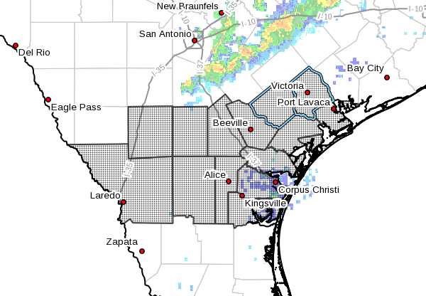
Tropical Depression Harvey Local Statement Advisory Number 14
National Weather Service Corpus Christi TX AL092017
1037 PM CDT Wed Aug 23 2017
This product covers SOUTH TEXAS
TROPICAL DEPRESSION HARVEY CONTINUES TOWARD THE TEXAS COAST
NEW INFORMATION
CHANGES TO WATCHES AND WARNINGS:
None
CURRENT WATCHES AND WARNINGS:
A Hurricane Watch is in effect for Bee, Goliad, Jim Wells, Live
Oak, and Victoria
A Storm Surge Watch and Hurricane Watch are in effect for
Aransas, Calhoun, Kleberg, Nueces, Refugio, and San Patricio
STORM INFORMATION:
About 490 miles southeast of Port Aransas TX or about 510 miles
south-southeast of Port Oconnor TX
21.9N 92.6W
Storm Intensity 35 mph
Movement Northwest or 325 degrees at 2 mph
SITUATION OVERVIEW
Tropical Depression Harvey continues to move very slowly over the
southern Gulf of Mexico. Harvey is expected to continue to
strengthen as it approaches the Texas coast Thursday into Friday.
Tropical storm force winds could approach coastal areas in the
Coastal Bend as early as Friday morning.
Heavy rainfall is expected through much of the area with rainfall
totals of 6 to 12 inches possible across the southern Coastal Bend
and 10 to 15 inches possible across the northern Coastal Bend and
Victoria Crossroads. Isolated higher amounts are possible. Lesser
amounts are expected further west. These numbers and locations are
subject to change depending on the exact point of landfall along the
Texas coast. Flash flooding is possible with these high rainfall
totals. The heaviest rains will occur Thursday night through
Saturday.
Peak Storm surge inundation is generally expected to be 4 to 6 feet
above ground level along and to the right of where the center
crosses the coast. Impacts would be felt along the barrier islands
and into the inland bays and waterways. Isolated locations could see
slightly higher inundation.
Tornadoes are possible as rainbands move onshore Thursday night
through Saturday.
POTENTIAL IMPACTS
FLOODING RAIN:
Prepare for dangerous rainfall flooding having possible significant
impacts across the Coastal Bend. Potential impacts
include:
Moderate rainfall flooding may prompt several evacuations and
rescues.
Rivers and tributaries may quickly become swollen with swifter
currents and overspill their banks in a few places, especially
in usually vulnerable spots. Small streams, creeks, canals, and
ditches overflow.
Flood waters can enter some structures or weaken foundations.
Several places may experience expanded areas of rapid
inundation at underpasses, low-lying spots, and poor drainage
areas. Some streets and parking lots take on moving water as
storm drains and retention ponds overflow. Driving conditions
become hazardous. Some road and bridge closures.
SURGE:
Prepare for life-threatening surge having possible significant
impacts across across the middle Texas coast and barrier islands. Potential
impacts in this area include:
Areas of inundation with storm surge flooding accentuated by
waves. Damage to several buildings, mainly near the coast.
Sections of near-shore escape routes and secondary roads become
weakened or washed out, especially in usually vulnerable low
spots.
Major beach erosion with heavy surf breaching dunes. Strong and
numerous rip currents.
Moderate damage to marinas, docks, boardwalks, and piers.
Several small craft broken away from moorings, especially in
unprotected anchorages.
Elsewhere across SOUTH TEXAS, little to no impact is anticipated.
WIND:
Prepare for life-threatening wind having possible extensive impacts
across the Coastal Bend. Potential impacts in this area
include:
Considerable roof damage to sturdy buildings, with some having
window, door, and garage door failures leading to structural
damage. Mobile homes severely damaged, with some destroyed.
Damage accentuated by airborne projectiles. Locations may be
uninhabitable for weeks.
Many large trees snapped or uprooted along with fences and
roadway signs blown over.
Some roads impassable from large debris, and more within urban
or heavily wooded places. Several bridges, causeways, and
access routes impassable.
Large areas with power and communications outages.
TORNADOES:
Prepare for a tornado event having possible limited impacts across
South Texas. Potential impacts include:
The occurrence of isolated tornadoes can hinder the execution
of emergency plans during tropical events.
A few places may experience tornado damage, along with power
and communications disruptions.
Locations could realize roofs peeled off buildings, chimneys
toppled, mobile homes pushed off foundations or overturned,
large tree tops and branches snapped off, shallow-rooted trees
knocked over, moving vehicles blown off roads, and small boats
pulled from moorings.
Elsewhere across SOUTH TEXAS, little to no impact is anticipated.
PRECAUTIONARY/PREPAREDNESS ACTIONS
EVACUATIONS:
If you are exceptionally vulnerable to wind or
water hazards from tropical systems, consider voluntary evacuation.
Relocate to a predetermined shelter or safe destination.
OTHER PREPAREDNESS INFORMATION:
Padre Island National Seashore will close its beaches to driving at
noon on Thursday.
Texas A & M – Corpus Christi has issued a mandatory evacuation for its
campus. All students and residents must vacate the campus by 7 am on
Thursday.
Texas A & M – Kingsville will be closing at 5 pm Thursday and will
remain closed through at least Sunday.
Now is the time to check your emergency plan and take necessary
actions to secure your home or business. Deliberate efforts should be
underway to protect life and property. Ensure that your Emergency
Supplies Kit is stocked and ready.
Closely monitor NOAA Weather Radio or other local news outlets for
official storm information. Listen for possible changes to the
forecast.
ADDITIONAL SOURCES OF INFORMATION:
For information on appropriate preparations see ready.gov
For information on creating an emergency plan see getagameplan.org
For additional disaster preparedness information see redcross.org
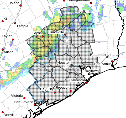
Tropical Depression Harvey Local Statement Advisory Number 14
National Weather Service Houston/Galveston TX AL092017
1029 PM CDT Wed Aug 23 2017
This product covers Southeast Texas
HARVEY DRIFTING ERRATICALLY NORTHWESTWARD TOWARDS THE TEXAS COAST AS
A TROPICAL DEPRESSION
NEW INFORMATION
CHANGES TO WATCHES AND WARNINGS:
None
CURRENT WATCHES AND WARNINGS:
A Storm Surge Watch and Hurricane Watch are in effect for
Brazoria, Jackson, and Matagorda
A Tropical Storm Watch is in effect for Austin, Colorado, Fort
Bend, Liberty, Waller, and Wharton
A Storm Surge Watch and Tropical Storm Watch are in effect for
Chambers, Galveston, and Harris
STORM INFORMATION:
About 530 miles south-southeast of Galveston TX
21.9N 92.6W
Storm Intensity 35 mph
Movement Northwest or 325 degrees at 2 mph
SITUATION OVERVIEW
Tropical Depression Harvey has not moved much today but is expected
to strengthen as it moves NW towards the Texas Coast. TD Harvey is
expected to continue to strengthen into a tropical storm or hurricane
during the next couple of days. The primary impact from Harvey remains
heavy rainfall and subsequent flooding, but there will still be a
threat for tropical storm to hurricane force winds and storm surge
along the coast. The most likely arrival time for Tropical Storm force
winds to reach the Upper Texas Coast is during the day on Friday.
Harvey is forecast to remain somewhere in the vicinity of S to SE Texas
through the weekend and will continue to pose a heavy rainfall and
flooding threat into early next week. Coastal flooding will likely be
an ongoing issue Friday through the weekend as tides will remain
elevated.
POTENTIAL IMPACTS
FLOODING RAIN:
Prepare for life-threatening rainfall flooding having possible
extensive impacts across Southeast Texas. Potential
impacts include:
Major rainfall flooding may prompt many evacuations and rescues.
Rivers and tributaries may rapidly overflow their banks in
multiple places. Small streams, creeks, canals, and ditches may
become dangerous rivers. Flood control systems and barriers
may become stressed.
Flood waters can enter many structures within multiple
communities, some structures becoming uninhabitable or washed
away. Many places where flood waters may cover escape routes.
Streets and parking lots become rivers of moving water with
underpasses submerged. Driving conditions become dangerous.
Many road and bridge closures with some weakened or washed out.
SURGE:
Prepare for life-threatening surge having possible significant
impacts across the Upper Texas Coast. Potential impacts in
this area include:
Areas of inundation with storm surge flooding accentuated by
waves. Damage to several buildings, mainly near the coast.
Sections of near-shore escape routes and secondary roads become
weakened or washed out, especially in usually vulnerable low
spots.
Major beach erosion with heavy surf breaching dunes. Strong and
numerous rip currents.
Moderate damage to marinas, docks, boardwalks, and piers.
Several small craft broken away from moorings, especially in
unprotected anchorages.
Also, prepare for locally hazardous surge having possible limited
impacts across northern Galveston Bay and Trinity Bay.
Elsewhere across Southeast Texas, little to no impact is anticipated.
WIND:
Prepare for dangerous wind having possible significant impacts across
the Upper Texas Coast, primarily near Matagorda Bay. Potential impacts
in this area include:
Some damage to roofing and siding materials, along with damage
to porches, awnings, carports, and sheds. A few buildings
experiencing window, door, and garage door failures. Mobile
homes damaged, especially if unanchored. Unsecured lightweight
objects become dangerous projectiles.
Several large trees snapped or uprooted, but with greater
numbers in places where trees are shallow rooted. Several
fences and roadway signs blown over.
Some roads impassable from large debris, and more within urban
or heavily wooded places. A few bridges, causeways, and access
routes impassable.
Scattered power and communications outages, but more prevalent
in areas with above ground lines.
TORNADOES:
Prepare for a tornado event having possible limited impacts across
Southeast Texas. Potential impacts include:
The occurrence of isolated tornadoes can hinder the execution
of emergency plans during tropical events.
A few places may experience tornado damage, along with power
and communications disruptions.
Locations could realize roofs peeled off buildings, chimneys
toppled, mobile homes pushed off foundations or overturned,
large tree tops and branches snapped off, shallow-rooted trees
knocked over, moving vehicles blown off roads, and small boats
pulled from moorings.
PRECAUTIONARY/PREPAREDNESS ACTIONS
EVACUATIONS:
If you are exceptionally vulnerable to wind or water hazards from
tropical systems, consider voluntary evacuation, especially if being
officially recommended. Relocate to a predetermined shelter or safe
destination.
If evacuating away from the area or relocating to a nearby shelter,
leave early before weather conditions become hazardous.
OTHER PREPAREDNESS INFORMATION:
Now is the time to check your emergency plan and take necessary
actions to secure your home or business. Deliberate efforts should be
underway to protect life and property. Ensure that your Emergency
Supplies Kit is stocked and ready.
When making safety and preparedness decisions, do not focus on the
exact forecast track as there are inherent forecast uncertainties
which must be taken into account.
If you live in a place that is particularly vulnerable to high wind,
such as a mobile home, an upper floor of a high rise building, or on
a boat, plan to move to safe shelter. Take enough supplies for you
and your family for several days.
If you live in a place particularly vulnerable to flooding, such as
near the ocean or a large inland lake, in a low lying or poor
drainage area, in a valley or canyon, or near an already swollen
river, plan to move to safe shelter on higher ground
Always heed the advice of local officials and comply with any orders
that are issued. Do not needlessly jeopardize your life or the lives
of others.
When securing your property, outside preparations should be conducted
as soon as possible before conditions deteriorate. The onset of
strong gusty winds and heavy rain can cause certain preparedness
activities to become unsafe.
Be sure to let friends and other family members know of your
intentions and whereabouts for surviving the storm. For emergency
purposes, have someone located away from the threatened area serve as
your point of contact. Share vital contact information with others.
Keep cell phones handy and well charged.
Be a Good Samaritan and check on those who may not be fully aware of
the situation or who are unable to make personal preparations.
Visitors to the area should become familiar with nearby surroundings.
If you are a visitor, know the name of the county or parish in which
you are located and where it is relative to current watches and
warnings. If staying at a hotel, ask the management staff about their
onsite disaster plan. Listen for evacuation orders, especially
pertaining to area visitors.
Closely monitor NOAA Weather Radio or other local news outlets for
official storm information. Listen for possible changes to the
forecast.
ADDITIONAL SOURCES OF INFORMATION:
For information on appropriate preparations see ready.gov
For information on creating an emergency plan see getagameplan.org
For additional disaster preparedness information see redcross.org
NEXT UPDATE
The next local statement will be issued by the National Weather
Service in Houston/Galveston TX around 430 AM CDT, or sooner if
conditions warrant.
SPRINGFIELD, Ill.) — Heavy rains often cause flooding in lowland areas, homes and basements. Safe Electricity reminds everyone to be alert to electrical equipment that could be energized and in contact with water, along with other potential hazards that create a serious danger of electric shock. Cleaning up and using water-damaged appliances also carry safety risks. As part of the “Teach Learn Care” TLC Campaign, Safe Electricity urges parents and other caregivers to make sure children are aware of these hazards as well.
“The prospect of an electrical accident is probably not top of mind when you’re dealing with a flooded basement, room or even outdoors,” said Molly Hall, executive director of Safe Electricity. “But it’s the first thing you should think of before you step foot in the water.”
Safety measures to keep in mind include:
Never step into a flooded basement or other room if water may be in contact with electrical outlets, appliances or cords.
Never attempt to turn off power at the breaker box if you must stand in water to do so. If you can’t reach your breaker box safely, call your electric utility to shut off power at the meter.
Never use electric appliances or touch electric wires, s
witches or fuses when you’re wet or when you’re standing in water.
Keep electric tools and equipment at least 10 feet away from wet surfaces. Do not use electric yard tools if it’s raining or the ground is wet.
If an electrical appliance has been in contact with water, have a professional check it out before it is used. It may need to be repaired or replaced.
“A good safety measure is to have ground fault circuit interrupters (GFCIs) professionally installed on outlets,” Hall said. “These safety devices can cut off power instantly if there’s a problem.”
GFCIs are recommended for outdoor outlets, and outlets near wet areas of the home such as kitchen, bath and laundry room. If time does not permit installation before a storm, you can purchase portable GFCIs from a hardware store.
Accidents and fires involving electricity result in more than a thousand deaths, and ten thousand injuries each year. Prevention of electricity-related tragedies is the goal of Safe Electricity.
# # #
The Energy Education Council is a 501 (c) 3 non-profit organization dedicated to promoting electrical safety and energy efficiency. Established in 1952, the Council is headquartered within the University of Illinois Extension, and serves as a forum for diverse utility and energy organizations to collaborate on the mutually vital issues of efficiency and safety. Learn more at www.EnergyEdCouncil.org.