

Tropical Depression Harvey Local Statement Advisory Number 14
National Weather Service Corpus Christi TX AL092017
1037 PM CDT Wed Aug 23 2017
This product covers SOUTH TEXAS
TROPICAL DEPRESSION HARVEY CONTINUES TOWARD THE TEXAS COAST
NEW INFORMATION
- CHANGES TO WATCHES AND WARNINGS:
- None
-
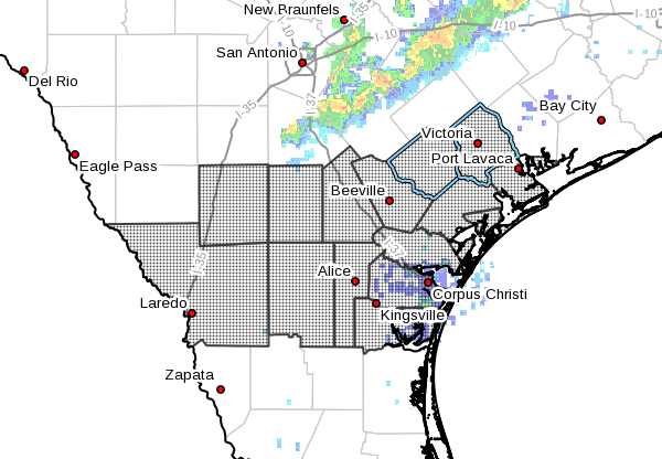
CURRENT WATCHES AND WARNINGS:
- A Hurricane Watch is in effect for Bee, Goliad, Jim Wells, Live
Oak, and Victoria -
A Storm Surge Watch and Hurricane Watch are in effect for
Aransas, Calhoun, Kleberg, Nueces, Refugio, and San Patricio -
STORM INFORMATION:
- About 490 miles southeast of Port Aransas TX or about 510 miles
south-southeast of Port Oconnor TX - 21.9N 92.6W
- Storm Intensity 35 mph
- Movement Northwest or 325 degrees at 2 mph
SITUATION OVERVIEW
Tropical Depression Harvey continues to move very slowly over the
southern Gulf of Mexico. Harvey is expected to continue to
strengthen as it approaches the Texas coast Thursday into Friday.
Tropical storm force winds could approach coastal areas in the
Coastal Bend as early as Friday morning.
Heavy rainfall is expected through much of the area with rainfall
totals of 6 to 12 inches possible across the southern Coastal Bend
and 10 to 15 inches possible across the northern Coastal Bend and
Victoria Crossroads. Isolated higher amounts are possible. Lesser
amounts are expected further west. These numbers and locations are
subject to change depending on the exact point of landfall along the
Texas coast. Flash flooding is possible with these high rainfall
totals. The heaviest rains will occur Thursday night through
Saturday.
Peak Storm surge inundation is generally expected to be 4 to 6 feet
above ground level along and to the right of where the center
crosses the coast. Impacts would be felt along the barrier islands
and into the inland bays and waterways. Isolated locations could see
slightly higher inundation.
Tornadoes are possible as rainbands move onshore Thursday night
through Saturday.
POTENTIAL IMPACTS
- FLOODING RAIN:
Prepare for dangerous rainfall flooding having possible significant
impacts across the Coastal Bend. Potential impacts
include: - Moderate rainfall flooding may prompt several evacuations and
rescues. - Rivers and tributaries may quickly become swollen with swifter
currents and overspill their banks in a few places, especially
in usually vulnerable spots. Small streams, creeks, canals, and
ditches overflow. - Flood waters can enter some structures or weaken foundations.
Several places may experience expanded areas of rapid
inundation at underpasses, low-lying spots, and poor drainage
areas. Some streets and parking lots take on moving water as
storm drains and retention ponds overflow. Driving conditions
become hazardous. Some road and bridge closures.
SURGE:
Prepare for life-threatening surge having possible significant
impacts across across the middle Texas coast and barrier islands. Potential
impacts in this area include:
waves. Damage to several buildings, mainly near the coast.
weakened or washed out, especially in usually vulnerable low
spots.
numerous rip currents.
Several small craft broken away from moorings, especially in
unprotected anchorages.
Elsewhere across SOUTH TEXAS, little to no impact is anticipated.
- WIND:
Prepare for life-threatening wind having possible extensive impacts
across the Coastal Bend. Potential impacts in this area
include: - Considerable roof damage to sturdy buildings, with some having
window, door, and garage door failures leading to structural
damage. Mobile homes severely damaged, with some destroyed.
Damage accentuated by airborne projectiles. Locations may be
uninhabitable for weeks. - Many large trees snapped or uprooted along with fences and
roadway signs blown over. - Some roads impassable from large debris, and more within urban
or heavily wooded places. Several bridges, causeways, and
access routes impassable. - Large areas with power and communications outages.
TORNADOES:
Prepare for a tornado event having possible limited impacts across
South Texas. Potential impacts include:
of emergency plans during tropical events.
and communications disruptions.
toppled, mobile homes pushed off foundations or overturned,
large tree tops and branches snapped off, shallow-rooted trees
knocked over, moving vehicles blown off roads, and small boats
pulled from moorings.
Elsewhere across SOUTH TEXAS, little to no impact is anticipated.
PRECAUTIONARY/PREPAREDNESS ACTIONS
- EVACUATIONS:
If you are exceptionally vulnerable to wind or
water hazards from tropical systems, consider voluntary evacuation.
Relocate to a predetermined shelter or safe destination.
OTHER PREPAREDNESS INFORMATION:
Padre Island National Seashore will close its beaches to driving at
noon on Thursday.
Texas A & M – Corpus Christi has issued a mandatory evacuation for its
campus. All students and residents must vacate the campus by 7 am on
Thursday.
Texas A & M – Kingsville will be closing at 5 pm Thursday and will
remain closed through at least Sunday.
Now is the time to check your emergency plan and take necessary
actions to secure your home or business. Deliberate efforts should be
underway to protect life and property. Ensure that your Emergency
Supplies Kit is stocked and ready.
Closely monitor NOAA Weather Radio or other local news outlets for
official storm information. Listen for possible changes to the
forecast.
- ADDITIONAL SOURCES OF INFORMATION:
- For information on appropriate preparations see ready.gov
- For information on creating an emergency plan see getagameplan.org
- For additional disaster preparedness information see redcross.org
Comments are closed.