

Tropical Depression Harvey Local Statement Advisory Number 14
National Weather Service Houston/Galveston TX AL092017
1029 PM CDT Wed Aug 23 2017
This product covers Southeast Texas
HARVEY DRIFTING ERRATICALLY NORTHWESTWARD TOWARDS THE TEXAS COAST AS
A TROPICAL DEPRESSION
NEW INFORMATION
- CHANGES TO WATCHES AND WARNINGS:
- None
-
CURRENT WATCHES AND WARNINGS:
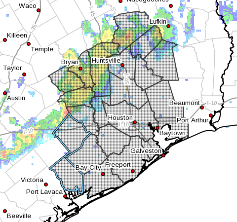
- A Storm Surge Watch and Hurricane Watch are in effect for
Brazoria, Jackson, and Matagorda - A Tropical Storm Watch is in effect for Austin, Colorado, Fort
Bend, Liberty, Waller, and Wharton -
A Storm Surge Watch and Tropical Storm Watch are in effect for
Chambers, Galveston, and Harris -
STORM INFORMATION:
- About 530 miles south-southeast of Galveston TX
- 21.9N 92.6W
- Storm Intensity 35 mph
- Movement Northwest or 325 degrees at 2 mph
SITUATION OVERVIEW
Tropical Depression Harvey has not moved much today but is expected
to strengthen as it moves NW towards the Texas Coast. TD Harvey is
expected to continue to strengthen into a tropical storm or hurricane
during the next couple of days. The primary impact from Harvey remains
heavy rainfall and subsequent flooding, but there will still be a
threat for tropical storm to hurricane force winds and storm surge
along the coast. The most likely arrival time for Tropical Storm force
winds to reach the Upper Texas Coast is during the day on Friday.
Harvey is forecast to remain somewhere in the vicinity of S to SE Texas
through the weekend and will continue to pose a heavy rainfall and
flooding threat into early next week. Coastal flooding will likely be
an ongoing issue Friday through the weekend as tides will remain
elevated.
POTENTIAL IMPACTS
- FLOODING RAIN:
Prepare for life-threatening rainfall flooding having possible
extensive impacts across Southeast Texas. Potential
impacts include: - Major rainfall flooding may prompt many evacuations and rescues.
- Rivers and tributaries may rapidly overflow their banks in
multiple places. Small streams, creeks, canals, and ditches may
become dangerous rivers. Flood control systems and barriers
may become stressed. - Flood waters can enter many structures within multiple
communities, some structures becoming uninhabitable or washed
away. Many places where flood waters may cover escape routes.
Streets and parking lots become rivers of moving water with
underpasses submerged. Driving conditions become dangerous.
Many road and bridge closures with some weakened or washed out.
SURGE:
Prepare for life-threatening surge having possible significant
impacts across the Upper Texas Coast. Potential impacts in
this area include:
waves. Damage to several buildings, mainly near the coast.
weakened or washed out, especially in usually vulnerable low
spots.
numerous rip currents.
Several small craft broken away from moorings, especially in
unprotected anchorages.
Also, prepare for locally hazardous surge having possible limited
impacts across northern Galveston Bay and Trinity Bay.
Elsewhere across Southeast Texas, little to no impact is anticipated.
- WIND:
Prepare for dangerous wind having possible significant impacts across
the Upper Texas Coast, primarily near Matagorda Bay. Potential impacts
in this area include: - Some damage to roofing and siding materials, along with damage
to porches, awnings, carports, and sheds. A few buildings
experiencing window, door, and garage door failures. Mobile
homes damaged, especially if unanchored. Unsecured lightweight
objects become dangerous projectiles. - Several large trees snapped or uprooted, but with greater
numbers in places where trees are shallow rooted. Several
fences and roadway signs blown over. - Some roads impassable from large debris, and more within urban
or heavily wooded places. A few bridges, causeways, and access
routes impassable. - Scattered power and communications outages, but more prevalent
in areas with above ground lines.
TORNADOES:
Prepare for a tornado event having possible limited impacts across
Southeast Texas. Potential impacts include:
of emergency plans during tropical events.
and communications disruptions.
toppled, mobile homes pushed off foundations or overturned,
large tree tops and branches snapped off, shallow-rooted trees
knocked over, moving vehicles blown off roads, and small boats
pulled from moorings.
PRECAUTIONARY/PREPAREDNESS ACTIONS
- EVACUATIONS:
If you are exceptionally vulnerable to wind or water hazards from
tropical systems, consider voluntary evacuation, especially if being
officially recommended. Relocate to a predetermined shelter or safe
destination.
If evacuating away from the area or relocating to a nearby shelter,
leave early before weather conditions become hazardous.
- OTHER PREPAREDNESS INFORMATION:
Now is the time to check your emergency plan and take necessary
actions to secure your home or business. Deliberate efforts should be
underway to protect life and property. Ensure that your Emergency
Supplies Kit is stocked and ready.
When making safety and preparedness decisions, do not focus on the
exact forecast track as there are inherent forecast uncertainties
which must be taken into account.
If you live in a place that is particularly vulnerable to high wind,
such as a mobile home, an upper floor of a high rise building, or on
a boat, plan to move to safe shelter. Take enough supplies for you
and your family for several days.
If you live in a place particularly vulnerable to flooding, such as
near the ocean or a large inland lake, in a low lying or poor
drainage area, in a valley or canyon, or near an already swollen
river, plan to move to safe shelter on higher ground
Always heed the advice of local officials and comply with any orders
that are issued. Do not needlessly jeopardize your life or the lives
of others.
When securing your property, outside preparations should be conducted
as soon as possible before conditions deteriorate. The onset of
strong gusty winds and heavy rain can cause certain preparedness
activities to become unsafe.
Be sure to let friends and other family members know of your
intentions and whereabouts for surviving the storm. For emergency
purposes, have someone located away from the threatened area serve as
your point of contact. Share vital contact information with others.
Keep cell phones handy and well charged.
Be a Good Samaritan and check on those who may not be fully aware of
the situation or who are unable to make personal preparations.
Visitors to the area should become familiar with nearby surroundings.
If you are a visitor, know the name of the county or parish in which
you are located and where it is relative to current watches and
warnings. If staying at a hotel, ask the management staff about their
onsite disaster plan. Listen for evacuation orders, especially
pertaining to area visitors.
Closely monitor NOAA Weather Radio or other local news outlets for
official storm information. Listen for possible changes to the
forecast.
- ADDITIONAL SOURCES OF INFORMATION:
- For information on appropriate preparations see ready.gov
- For information on creating an emergency plan see getagameplan.org
- For additional disaster preparedness information see redcross.org
NEXT UPDATE
The next local statement will be issued by the National Weather
Service in Houston/Galveston TX around 430 AM CDT, or sooner if
conditions warrant.
Comments are closed.