Home

TTR News Center

TTR Weather Update from NWS Corpus Christi including information for Calhoun, Goliad, and Victoria Counties.

No Comments Local News

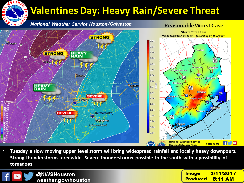
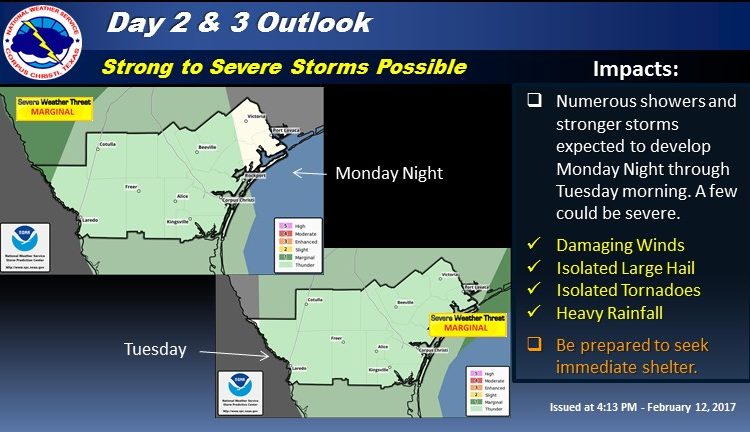
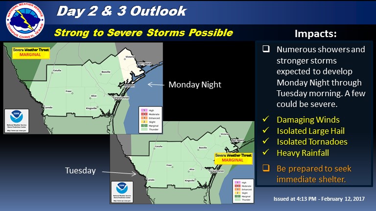
There is a possibility for strong, possibly severe, thunderstorms very early Tuesday morning across the Rio Grande Plains and again later Tuesday morning/early afternoon across the Northern Coastal Bend and Victoria Crossroads areas. This is currently a lower than average confidence forecast in terms of cold front timing on Tuesday. An earlier/quicker cold front passage than currently expected may greatly reduce the strength of any storms that develop Tuesday, thus greatly limiting the severe thunderstorm threat. Heavy rainfall will also be a factor with this system north and east of Highway 281 Tuesday.

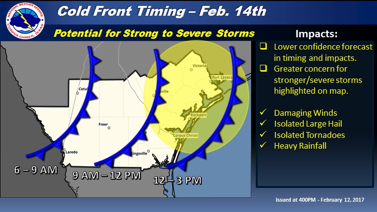
Timing and Overview:

Stronger storms may develop across portions of the Edwards Plateau Monday and move into portions of the Rio Grande Plains very early Tuesday morning. Meanwhile, a cold front moving in from the west later Tuesday morning may allow more strong to possibly severe thunderstorms to develop as it crosses the Coastal Bend. Please see the cold front timing image below for our areas of greatest concern in South Texas. As stated before, timing for the cold front is lower than average confidence at this time. It may take until later Monday to be able to provide a more concrete timing and impacts from its passage. Please stay tuned.

South Texas Impacts:

Tornadoes:  Isolated tornadoes possible across the Coastal Bend and Victoria Crossroads areas.


Winds:
  Strong to possibly damaging winds. In excess of 50 to 60 mph.
Hail:  Isolated 1″ hail possible.
Rainfall:  Less than 0.5 inches south to 1-1.5 inches across Victoria Crossroads possible. Most of this rain could fall in a very brief amount of time.

c


dAdditional Information Resources:

NWS Corpus Christi Webpagewww.weather.gov/corpuschristi 
Storm Prediction Centerwww.spc.noaa.gov/
Online Severe Weather Reportinghttps://www.srh.noaa.gov/StormReport/SubmitReport.php?site=crp

Sincerely,
Greg Heavener
NWS Corpus Christi, TX

TTR Weather Update from NWS Houston-Galveston including information for Colorado, Jackson, and Wharton Counties

No Comments Local News

Valentines Day still looking like an active day with storms moving through the region. Here is the current thinking on the timing and severe location.

IMG_1830 IMG_1831

Overview:

An area of showers and thunderstorms will move through the region Tuesday bringing heavy rainfall and possibly severe weather.

The timing of the storms should be moving through between 8 am and 5 pm.

Brief Tornadoes:  Isolated tornadoes possible across the southern portions of the area mainly along and south of the I-10 corridor.

Winds:
  Strong to possibly damaging winds. In excess of 50 to 60 mph.

Hail:  Small hail possible.

Rainfall amounts of 1-2 inches will be common with isolated amounts of 3-5 inches. If the storms cluster up along the frontal boundary then greater amounts will be possible.

b

NWS Houston/Galveston Webpagewww.weather.gov/hgx
Online Severe Weather Reportinghttps://www.srh.noaa.gov/StormReport/SubmitReport.php?site=hgx

Kent Prochazka
NWS Houston/Galveston

TTR Weather Update from NWS Houston-Galveston includes information for Colorado, Jackson, and Wharton Counties.

No Comments Local News

IMG_1769
Warm weather with record setting temperatures on tap today and Sunday but this will probably come at some cost. Very moist air flowing into the area will bring fog to the coast and at times will be dense through Tuesday morning.

Tuesday a potent storm system will move through the area. This system will bring widespread rainfall of 1 to 2 inches across the area. Some indications of heavy rainfall may focus this rainfall further south.

This image shows the areas most likely to see rainfall on the left and the right image is a reasonable worst case if rainfall focuses closer to the coast and along the warm front that will be in the area. In addition the areas mainly south of a Columbus to Conroe to Livingston line may see strong to severe thunderstorms in a highly sheared environment favorable for tornadoes.

It is still early but models have been consistent on the threat for heavy rain…not so consistent on severe signal and much will depend on the eventual track of the low through the area.

Kent Prochazka/Melissa Huffman
NWS Houston/Galveston


TTR Weekend Weather

No Comments Local News

image4
Above normal temperatures are expected Saturday and Sunday. A cold front will bring some light showers as it moves across South Central Texas midday to afternoon on Sunday. Periods of showers and thunderstorms are expected Sunday night through Tuesday night with a potential for heavier rains as an upper level storm system approaches. The system will move off to the east with rains ending on Wednesday. Below normal temperatures are expected Monday through Wednesday.

Untitled

Now, here’s your TTR Weekend Weather from the National Weather Service in Austin – San Antonio:

Today
Mostly cloudy with a 20 percent chance of showers. Highs in the mid 70s. Southeast winds 10 to 15 mph.

Tonight
Warmer, cloudy. Slight chance of sprinkles. Lows in the mid 60s. South winds 10 mph.

Saturday
Mostly cloudy. Slight chance of sprinkles. Highs in the lower 80s. South winds 10 to 20 mph.

Saturday Night
Mostly cloudy. Lows in the mid 60s. South winds 10 to 15 mph.

Sunday
Mostly cloudy. Slight chance of sprinkles. Highs in the upper 70s. South winds 5 to 10 mph shifting to the east in the afternoon.

Sunday Night
Cloudy with chance of showers and slight chance of thunderstorms. Lows in the upper 50s. Chance of rain 40 percent.

Texas Fire Potential Update:

The state has not seen much rain over the past two weeks and there have been periods of accelerated drying followed by short periods of higher dewpoints and higher Relative Humidity. Most of the fire activity on the 7 day map occurred early last week during a period of accelerated drying. We have seen a pause in fire occurrence since Thursday when cooler air and increased surface moisture moved into the state. The next 7 days will see dry air expanding across the state from west to east starting Monday. Surface fuels will quickly dry with the warm dry air.

tfs

In Texas, local governments are empowered to take action on the behalf of those they serve. When drought conditions exist, a burn ban can be put in place by a county judge or county commissioners court prohibiting or restricting outdoor burning for public safety. Locally, a Burn Ban is in effect for all of De Witt County, Texas.

DecBan
Have a great weekend,

TTR

Dense Fog Advisory including Gonzales, TX, and Caldwell, TX

No Comments Local News

URGENT – WEATHER MESSAGE
NATIONAL WEATHER SERVICE AUSTIN/SAN ANTONIO TX
1023 PM CST SAT FEB 4 2017

TXZ171>173-184>193-203>208-219>223-051230-
/O.NEW.KEWX.FG.Y.0006.170205T0423Z-170205T1600Z/
LLANO-BURNET-WILLIAMSON-EDWARDS-REAL-KERR-BANDERA-GILLESPIE-
KENDALL-BLANCO-HAYS-TRAVIS-BASTROP-UVALDE-MEDINA-BEXAR-COMAL-
GUADALUPE-CALDWELL-FRIO-ATASCOSA-WILSON-KARNES-GONZALES-
INCLUDING THE CITIES OF LLANO, BURNET, GEORGETOWN, ROCKSPRINGS,
LEAKEY, KERRVILLE, BANDERA, FREDERICKSBURG, BOERNE, BLANCO,
SAN MARCOS, AUSTIN, BASTROP, UVALDE, HONDO, SAN ANTONIO,
NEW BRAUNFELS, SEGUIN, LOCKHART, PEARSALL, PLEASANTON,
FLORESVILLE, KARNES CITY, AND GONZALES
1023 PM CST SAT FEB 4 2017

…DENSE FOG ADVISORY IN EFFECT UNTIL 10 AM CST SUNDAY…

THE NATIONAL WEATHER SERVICE IN AUSTIN/SAN ANTONIO HAS ISSUED A
DENSE FOG ADVISORY, WHICH IS IN EFFECT UNTIL 10 AM CST SUNDAY.

  • VISIBILITY…ONE QUARTER MILE OR LESS
  • IMPACTS…AREAS OF DENSE FOG WILL REDUCE VISIBILITY CAUSING
    HAZARDOUS DRIVING CONDITIONS.

PRECAUTIONARY/PREPAREDNESS ACTIONS…

A DENSE FOG ADVISORY MEANS VISIBILITIES WILL FREQUENTLY BE
REDUCED TO A QUARTER MILE OR LESS. IF DRIVING…SLOW DOWN…USE
YOUR HEADLIGHTS…AND LEAVE PLENTY OF DISTANCE AHEAD OF YOU.