…Elevated Fire Weather Conditions Expected Saturday…
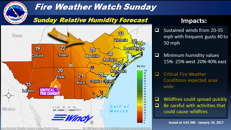
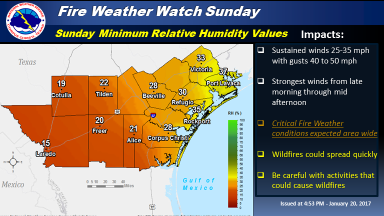
…A Fire Weather Watch is in effect for South Texas from Late Morning Sunday through Sunday Afternoon…
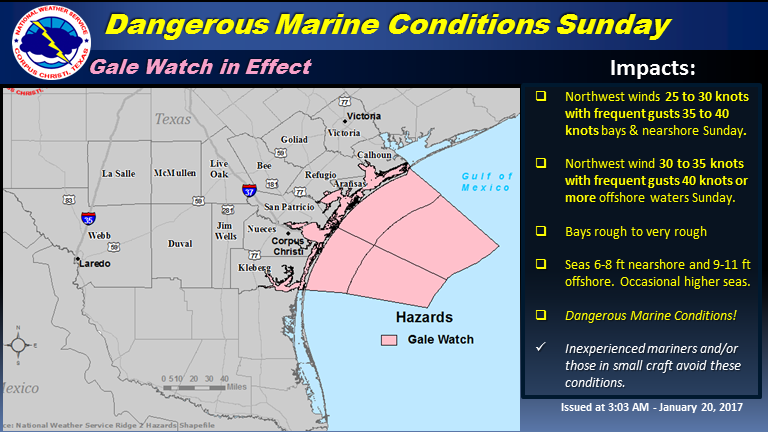
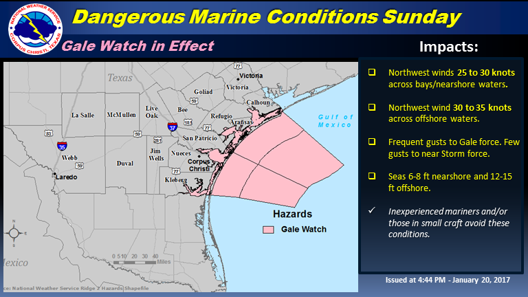
…A Gale Watch is in effect for the Bays and Middle Texas Coastal Waters from Late Saturday Night through Sunday Evening…
Timing and Overview:
A dryline-like feature is forecast to shift east across the Brush Country Saturday afternoon. This will result in a lowering of relative humidity values and an increase in westerly wind speeds, which may result in an elevated fire danger for Saturday afternoon for the Brush Country.
A cold front is expected to move across the region Saturday night with a strong to very strong northwest wind developing in its wake Sunday. The strong wind combined with very low relative humidity will lead to critical to extremely critical fire weather conditions across South Texas. In addition, gale conditions are expected across marine areas Sunday. As a result, a Fire Weather Watch and Gale Watch are in effect for South Texas and the Middle Texas Coastal Waters, respectively.
South Texas Fire Weather Impacts:
Wind:
- Saturday: Light/variable in the morning, becoming west 10-20 mph and a little gusty in the afternoon across the Brush Country. Lighter SSW winds are expected across the Coastal Plains to Victoria.
- Sunday: West to northwest wind 25 to 35 mph with frequent gusts 40 to 50 mph. However, the potential exists for greater sustained wind speed and gust magnitudes.
Humidity:
- Saturday: minimum relative humidity values of 15% to 25% across the Brush Country. Higher values elsewhere.
- Sunday: Minimum relative humidity values of 15 to 20 percent over the Rio Grande Plains to 25 to 35 percent over the Coastal Bend and over the Victoria Crossroads.
Impacts:
- Any fires that develop will likely spread rapidly. Extreme resistance to control efforts will occur over the Rio Grande Plains.
- Substantial resistance to control efforts will occur over the Coastal Bend and Victoria Crossroads.
Marine Impacts:
Wind:
- NW 25 to 30 knots with frequent gusts to gale force across bays and nearshore waters.
- NW 30 to 35 knots and frequent gale force winds across offshore waters.
- Brief gusts to storm force will be possible across offshore waters.
Seas/Bays:
- Bays rough to occasionally very rough.
- Seas building to 6 to 8 feet nearshore and 12 to 15 feet offshore.
Impacts:
- Operating a vessel in gale conditions requires experience and properly equipped vessels.
- It is highly recommended that mariners without the proper experience seek safe harbor prior to the onset of gale conditions.
Additional Information Resources:
NWS Corpus Christi Marine Webpage: https://www.weather.gov/crp/mar
NWS Corpus Christi Fire Weather Webpage: www.weather.
Texas Forest Service Predictive Services: https://ticc.tamu.ed
Rob Hart
Forecaster
NWS Corpus Christi, TX