Home

TTR News Center

TTR Weather Update

No Comments Local News

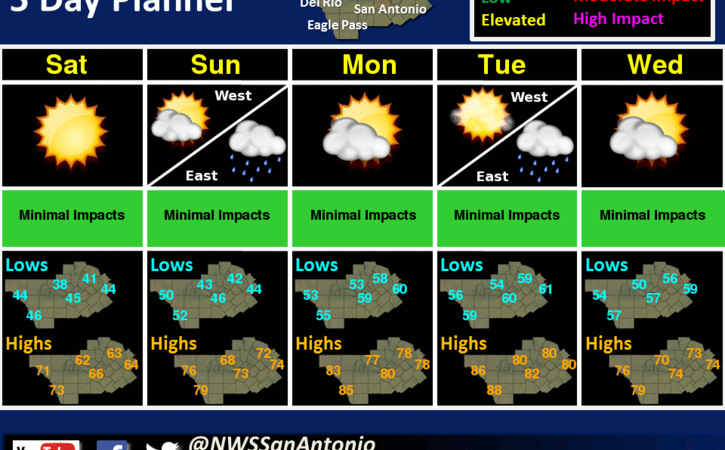
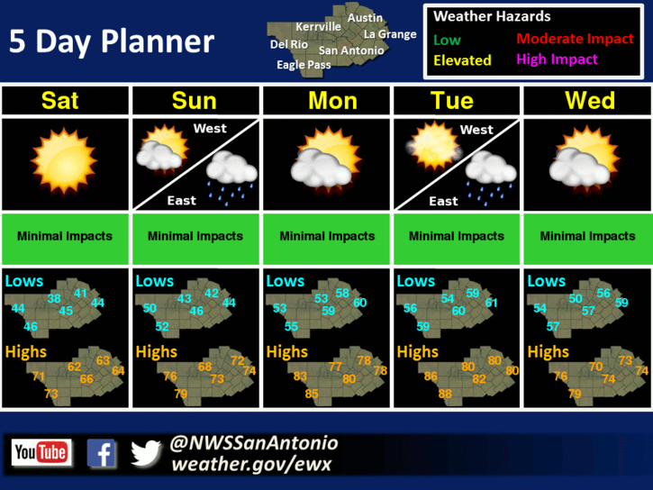
An upper level disturbance will bring numerous to widespread showers on Saturday into Saturday night. The showers will slowly end from west to east on Sunday as the disturbance moves off to the east. Residual moisture may allow for some sprinkles on Monday. A cold front will bring showers and thunderstorms on Tuesday into Tuesday night and showers on Wednesday. Below normal temperatures on Saturday will warm to above normal Sunday through Tuesday, then fall back closer to normal on Wednesday.

image4
Now, here’s your TTR Weather Forecast from the National Weather Service Austin-San Antonio:

Tonight: Cloudy. A 20 percent chance of showers after midnight. Lows in the lower 50s. East winds 5 to 10 mph.

Saturday: Showers. Highs in the mid 60s. East winds 10 to 15 mph. Chance of rain 90 percent.

Saturday Night: Showers. Near steady temperature in the lower 60s. East winds 10 to 15 mph. Chance of rain 80 percent.

Sunday: Cloudy with a 50 percent chance of showers. Highs in the mid 70s. Southeast winds 10 to 15 mph.

Sunday Night: Mostly cloudy. A 20 percent chance of showers before midnight. Lows in the mid 60s. Southeast winds 10 to 15 mph.

Monday: Mostly cloudy with a 20 percent chance of showers. Highs around 80.

Monday Night: Partly cloudy before midnight then becoming mostly cloudy. Slight chance of showers and isolated thunderstorms. Lows in the upper 60s. Chance of rain 20 percent.

Tuesday: Cloudy with a 50 percent chance of showers and thunderstorms. Highs in the upper 70s.

Tuesday Night: Cooler. Mostly cloudy with a 30 percent chance of showers and thunderstorms. Lows in the upper 50s.

Wednesday And Wednesday Night: Mostly cloudy. Highs around 70. Lows in the mid 50s.

Thursday: Mostly cloudy with a 30 percent chance of showers. Highs in the lower 70s.

Thursday Night: Mostly cloudy before midnight then becoming partly cloudy. Lows in the upper 50s.

Friday: Partly cloudy with a 20 percent chance of showers. Highs in the mid 70s.

GBRA to Host Public Meeting on Lake Wood Issues – Dam Gate Replacement Options and Funding Opportunities to be Discussed

No Comments Local News

GONZALES, Texas – Guadalupe-Blanco River Authority (GBRA) officials will host a public meeting on issues involving Lake Wood beginning at 5:30 p.m. Thursday, March 9, 2017, at the City of Gonzales Expo Center at J.B. Wells, 2301 County Road 197, in Gonzales, Texas.

GBRA staff will provide information about its hydroelectric system , dam gate replacement options for Lake Wood, and potential funding opportunities for the gate replacement. Local constituents are invited to attend the meeting, see the presentations and address questions to GBRA staff.

GBRA Communications and Education staff disseminates press releases to local media and posts accordingly on the press release page of GBRA’s website: www.gbra.org. Information also is shared on GBRA’s social media accounts through Instagram and Twitter “@GBRATX” and Facebook at “GBRA of Texas.”

The GBRA was established by the Texas Legislature in 1933 as a water conservation and reclamation district. GBRA provides stewardship for the water resources in its 10-county statutory district, which begins near the headwaters of the Guadalupe and Blanco rivers, ends at San Antonio Bay, and includes Kendall, Comal, Hays, Caldwell, Guadalupe, Gonzales, DeWitt, Victoria, Calhoun, and Refugio counties.

TTR Weekend Weather Update

No Comments Local News

The Flood Warning continues for the Guadalupe River Near Bloomington affecting Calhoun, Refugio, and Victoria Counties. Rainfall earlier this week upstream and over the area will keep the aforementioned river above flood stage for the next few days.  For the latest river stages and forecasts visit: https://txthunderradio.com/river/

image4
Behind a cold front, temperatures will drop to near normal on Saturday. A warming trend with increasing moisture will begin on Sunday and continue through Tuesday. An upper level disturbance will generate isolated showers and thunderstorms Sunday into Sunday night. Isolated showers are also possible on Tuesday across the eastern areas.

Now here’s your TTR Weekend Weather Forecast –

Today: Partly cloudy in the morning then clearing. Patchy fog early in the morning. Highs in the lower 80s. West winds 5 to 10 mph shifting to the north 10 to 15 mph in the afternoon.

Tonight: Cooler, clear. Lows in the mid 40s. North winds 5 to 10 mph.

Saturday: Cooler, sunny. Highs in the mid 60s. Northeast winds 10 to 15 mph.

Saturday Night: Clear. Lows in the upper 40s. East winds 5 mph.

Sunday: Partly cloudy with a slight chance of showers in the morning, then mostly cloudy with a slight chance of showers and thunderstorms in the afternoon. Highs in the mid 70s. Southeast winds 10 to 15 mph. Chance of rain 20 percent.

Sunday Night And Monday: Mostly cloudy with a 20 percent chance of showers. Lows in the lower 60s. Highs in the upper 70s.

Have a great weekend!

TTR Weather Update from NWS Houston-Galveston. Includes information for Colorado, Jackson, and Wharton Counties.

No Comments Local News

TGIF! But a wet one. Today – look for one storm system over the area to continue to push east. Some areas  got a good 0.25 to 0.5 inches of rain with higher amounts along the coast. Saturday – High temperatures in the low 80s.

5

Heavy Rainfall Potential – overall not much change in the overall thinking from previous forecast.

Timing – 6PM Sunday to 6PM Monday. Possible for some lingering rain Monday night but not heavy.

Locations – Over much of SE Texas but largely depends on where axis of higher moisture is located. This could end up being east of the area so still low/medium confidence on location of heavy rainfall.

Rainfall Amounts – overall 2 to 4 inches in this 24 hour period with isolated higher amounts. Still hard to pinpoint what those isolated higher amounts may be. Higher amounts will be embedded within axis of higher moisture.

Impacts – still the potential for minor river flooding and rapid increases on area bayous. Street flooding possible in low lying areas. Flash flooding looks possible but will depend on how quickly rainfall occurs.

6


Links

NWS Houston/Galveston Webpage: www.weather.gov/houston

West Gulf River Forecast Center: https://www.weather.gov/wgrfc/

AHPS Webpage: https://water.weather.gov/ahps2/index.php?wfo=hgx

Forecasters – Scott Overpeck, Wendy Wong
National Weather Service
Houston – Galveston, Texas

TTR Weather Update from NWS Austin – San Antonio. Includes information for Caldwell, De Witt, Fayette, Gonzales, Karnes, and Lavaca Counties.

No Comments Local News

…Locally Heavy Rainfall Possible Sunday Night…

…Strong Storms Possible Sunday Afternoon and Sunday Night…

Timing and Area of Concern:

  • Heavy Rainfall:  Primarily near and east of Interstate 35 and I-37 Sunday Night, including Austin metro.
  • Strong to Severe Storms:  Hill Country and along and east of I-35 Sunday afternoon and Sunday Night.

Threats & Impacts:

Rainfall:  1-2 inches with isolated amounts over 4 inches near and east of I-35 and I-37, including the Austin metro area. Around 1 inch over the San Antonio metro area is expected. Less than 1 inch farther west of I-35 and I-37. Please reference overview and confidence sections below for uncertainty.

  • Some locations could experience minor flooding with flood waters capable of causing small streams, creeks, canals, and ditches to become swollen and overflow in a few places. Flood waters may prompt brief closures of low water crossings. Some river points along the Lower Guadalupe River could experience minor flooding. Other mainstem river basins east of I-35 in South Central Texas could see points in action stage.

Hail: Up to 1 inch in diameter

Winds: Up to 60 mph

Overview:

A strong upper level disturbance will move across the region Sunday afternoon and Sunday night. Showers will form Sunday morning with scattered thunderstorms possible Sunday afternoon. The showers and storms will become more widespread Sunday evening from the eastern Hill Country through the I-35 corridor and then transition east of I-35 overnight Sunday into Monday. The greatest potential for heavy rainfall looks to occur near and east of I-35 and I-37 where 1-2 inches of rain with isolated amounts over 4 inches will be possible. The threat for heavy rainfall will move east into Southeast and East Texas Monday morning.

There will also be be a threat some storms could become strong to marginally severe Sunday afternoon and Sunday night. Any of these storms will be capable of producing small hail and damaging straight-line wind gusts.

Confidence:

Low to moderate on exact placement of heavy rainfall corridor across Texas. There is still some uncertainty that heavier rainfall amounts could be pulled into and just west of the I-35 corridor, including the cities of San Antonio and Austin. Please monitor forecasts closely through the holiday weekend for any potential westward shift in heavier rainfall into the I-35 corridor and eastern Hill Country.

Sun-Mon Threats

Additional Information Resources:

Sincerely,
Jason Runyen

NWS Austin / San Antonio

Weather Forecast Office
2090 Airport Road
New Braunfels, TX 78130