Home

TTR News Center

Morning freezes expected across most of the area this weekend.

No Comments Local News

image4-1

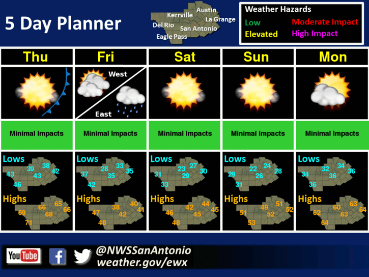
Temperatures will warm briefly on Thursday ahead of another cold front set to move into the region Thursday evening. The cold air push behind this front will last through early Saturday with morning freezes expected across most areas from Friday through Sunday. There is a slight chance of light rain along and east of Highway 281 during the daytime and evening on Friday, but temperatures are currently expected to be above freezing during this period of possible precipitation. A warming trend is expected for next week.

Now, here’s your TTR Weather forecast from the National Weather Service Austin/San Antonio:

Today: Much cooler. Partly cloudy. Highs in the mid 50s. North winds 10 to 15 mph.

Tonight: Partly cloudy. Lows in the mid 40s. Northeast winds 5 mph shifting to the south after midnight.

Thursday: Partly cloudy in the morning then becoming mostly cloudy. Highs in the mid 60s. Southwest winds 5 to 10 mph.

Thursday Night: Mostly cloudy. Lows in the upper 30s. North winds 10 to 20 mph.

Friday: Much colder. Cloudy with a 20 percent chance of rain. Highs in the lower 40s. North winds 15 to 20 mph.

Friday Night: Mostly cloudy. A 20 percent chance of rain before midnight. Lows in the lower 30s. Wind chill readings 25 to 30.

Saturday: Partly cloudy in the morning then clearing. Highs in the mid 40s. Lowest wind chill readings 20 to 25 in the morning.

Saturday Night: Mostly clear. Lows in the upper 20s.

Sunday: Sunny. Highs in the lower 50s.

Sunday Night: Mostly clear. Lows in the upper 30s.

NWS UPDATE FOR Colorado, Jackson, and Wharton Counties – Severe Thunderstorms Possible Tonight – Monday AM

No Comments Local News

img_0414 img_0415 img_0416

Overview: Scattered thunderstorms are expected to develop across parts of West and West Central Texas tonight and grow into a large thunderstorm complex that will move from west to east across the state. Ahead of this complex, isolated showers and thunderstorms may develop across Southeast Texas that pose a damaging wind or brief tornado threat before the main thunderstorm complex moves across the region. This complex will move quickly east, with dry and warm conditions expected across the region after 12 PM.

While the thunderstorm complex will be capable of heavy rain, the speed at which it moves across the region will minimize any flooding threat these storms pose.

Changes Since Last Briefing: Minor refinements to timing and impacted locations

Hazards: Thunderstorms capable of damaging winds, hail, and isolated tornadoes

Timing: 4 AM – Noon Monday (Travel impacts during the morning commute possible)

Location: Severe weather will be possible across most of Southeast Texas tonight into
Monday morning, with best potential at this time appearing to be north of the Highway 59 corridor.

Melissa Huffman & Josh Lichter
NWS Houston/Galveston

Slight Risk for Severe Storms Late Tonight through Early Monday Morning

No Comments Local News

Timing & Area of Concern:

The greatest risk for storms will be along and north of a Del Rio to Uvalde to Victoria line.

12 AM – 3 AM: Rio Grande and Western Edwards Plateau
2 AM – 5 AM: Hill Country (West of I-35)
4 AM – 8 AM: Along and East of I-35
Threats & Impacts:

Hail: Quarter sized or greater.

Winds: Isolated wind gusts up to 60 mph.

Tornadoes: An isolated tornado is possible, mainly along and east of I-35 corridor.

Rainfall: 1/4-1/2 inch with isolated amounts up to 1 inch for the eastern Hill Country, Central Texas, and areas east of I-35. Less than 1/4 inch Rio Grande, Western Hill Country, and remainder of South Texas. Due to the speed of this system no significant flash flooding is expected.

Overview:

A potent upper level disturbance and Pacific cold front will generate a quick round of showers and storms late tonight through early Monday morning. The best chances for storms will be along and north of a Del Rio to Uvalde to Victoria line. Environmental conditions are favorable for some isolated storms to produce large hail in addition to damaging wind gusts across the region. In addition, a lower threat of an isolated tornado can’t be ruled out, mainly along and east of the I-35 corridor. The Storm Prediction Center has placed much of the area under a Slight Risk for severe storms tonight, but the area with the highest potential for severe weather is in red in the attached image.

img_0407

Confidence:

Moderate

Additional Information Resources:
NWS Austin / San Antonio Webpage: https://www.weather.gov/sanantonio
Storm Prediction Center: https://www.spc.noaa.gov/
Online Severe Weather Reporting: https://www.srh.noaa.gov/StormReport/SubmitReport.php?site=EWX

Sincerely,
Nick Hampshire & Jon Zeitler

NWS Austin / San Antonio
Weather Forecast Office

⚡️ Severe Storms possible on Sunday, and your TTR Weekend Weather Forecast

No Comments Local News

image4
A few disturbances over the next few days will provide an opportunity for some rain and even some possible strong storms come Sunday night and Monday morning. The risk for severe storms is marginal for Sunday through Monday morning with some possible hail. Then a strong cold front will look to impact the region come Wednesday morning bringing much cooler temperatures into the late week.

image5
There is a marginal risk for severe weather on Sunday night and lasting through Monday morning as an upper level shortwave moves over the state. The primary threat will be hail up to one inch in diameter.

Now here’s your TTR Weekend Weather Forecast –

Tonight
Cloudy with a 50 percent chance of showers. Near steady temperature in the mid 50s. Southeast winds 5 mph.

Saturday
Cloudy. Showers likely in the morning…then a chance of showers in the afternoon. Highs in the upper 60s. Southwest winds 5 to 10 mph. Chance of rain 70 percent.

New Years Eve
Mostly cloudy. Lows in the upper 50s. Southwest winds 5 mph shifting to the east after midnight.

New Years Day
Mostly cloudy with a 20 percent chance of showers. Highs in the mid 70s. Southeast winds 5 to 10 mph.

Sunday Night
Mostly cloudy with a 50 percent chance of showers and thunderstorms. Lows in the mid 60s.
mid 40s.

decban

FIRE WEATHER PLANNING FORECAST FOR SOUTH CENTRAL TEXAS
NATIONAL WEATHER SERVICE AUSTIN/SAN ANTONIO TX
422 AM CST FRI DEC 30 2016

.DISCUSSION...
LOW MINIMUM RH VALUES AROUND 25-30 PERCENT TODAY...HOWEVER
SOUTHERLY WINDS RESUMING WILL BE RELATIVELY WEAK. A SERIES OF
DISTURBANCES FROM THE PACIFIC WILL GENERATE CHANCES FOR RAIN TODAY
THROUGH MONDAY. THERE WILL BE A SLIGHT CHANCE OF RAIN TODAY AND
A BETTER CHANCE TONIGHT INTO SATURDAY MORNING ACROSS SOUTH
CENTRAL TEXAS. A CHANCE OF SHOWERS AND THUNDERSTORMS WILL
OCCUR LATE SUNDAY INTO MONDAY MORNING WITH A STRONGER DISTURBANCE.
A PACIFIC COLD FRONT WILL MOVE THROUGH THE AREA MONDAY BEHIND THE
DEPARTING DISTURBANCE...BRINING MINIMUM RH VALUES OUT WEST OF
AROUND 30 PERCENT MONDAY AFTERNOON. WESTERLY WINDS HOWEVER SHOULD
REMAIN BELOW RED FLAG CRITERIA. A STRONG ARCTIC FRONT WILL MOVE
THROUGH THE REGION ON WEDNESDAY BRINGING MUCH COLDER WEATHER AND
ANOTHER CHANCE OF RAIN.
KARNES-DE WITT-LAVACA-
INCLUDING THE CITIES OF...KARNES CITY...CUERO...HALLETSVILLE
422 AM CST FRI DEC 30 2016

                      TODAY        TONIGHT      SAT

CLOUD COVER           MCLDY        CLOUDY       CLOUDY
CHANCE PRECIP (%)     10           50           60
PRECIP TYPE           SPRINKLES    SHOWERS      SHOWERS
TEMP (24H TREND)      60 (-6)      52 (+6)      69
RH % (24H TREND)      25 (+3)      96 (-4)      71
20FTWND-AM(MPH)       NE  6                     W  6
20FTWND-PM(MPH)       SE  6        SE  5        SW  6
MIXING HGT(FT-AGL)    3434                      800
TRANSPORT WND (MPH)   SE 12                     W  8
CWR                   0            10           40
LAL                   1            1            1
HAINES INDEX          3            2            2

REMARKS...NONE.

.FORECAST FOR DAYS 3 THROUGH 7...

.NEW YEARS DAY...MOSTLY CLOUDY WITH CHANCE OF THUNDERSTORMS AND
SLIGHT CHANCE OF RAIN SHOWERS. LOWS IN THE UPPER 50S. HIGHS IN
THE MID 70S. SOUTHEAST WINDS UP TO 10 MPH.
.MONDAY...PARTLY CLOUDY. A 50 PERCENT CHANCE OF SHOWERS AND
THUNDERSTORMS. LOWS IN THE MID 60S. HIGHS IN THE UPPER 70S. WEST
WINDS 5 TO 10 MPH.
.TUESDAY...MOSTLY CLEAR. LOWS IN THE LOWER 50S. HIGHS IN THE
UPPER 70S. EAST WINDS UP TO 5 MPH.
.WEDNESDAY...PARTLY CLOUDY. A 30 PERCENT CHANCE OF RAIN. COOLER.
LOWS IN THE LOWER 50S. HIGHS IN THE LOWER 60S. NORTH WINDS 5 TO
15 MPH.
.THURSDAY...CLOUDY WITH A 50 PERCENT CHANCE OF RAIN. COOLER. LOWS
IN THE LOWER 40S. HIGHS IN THE MID 40S. NORTH WINDS 10 TO 15 MPH.

TTR Weekend Weather Update

No Comments Local News

img_0088

Near average temperatures will continue across South Central Texas on Today. Cloud cover and moisture will increase this afternoon as rain chances increase with light showers possible over most of the region on Christmas Eve and isolated to scattered showers and a few thunderstorms possible on Christmas. A cold front is forecast to stall over central Texas on Monday with isolated to scattered showers and thunderstorms over much of the region. Scattered showers are expected on Tuesday. Temperatures will be above average over the weekend through Tuesday.

Now, here’s your Texas Thunder Radio Weekend Weather Forecast from the National Weather Service Austin – San Antonio…

Today
Cloudy with chance of showers and patchy drizzle. Highs in the lower 70s. South winds 10 to 15 mph. Chance of rain 40 percent.
Tonight
Cloudy with chance of showers and areas of drizzle. Areas of fog. Lows in the mid 60s. Southeast winds 5 to 10 mph. Chance of rain 40 percent.
Saturday
Mostly cloudy. Areas of fog in the morning. Chance of showers and areas of drizzle in the morning…then a chance of showers in the afternoon. Highs in the mid 70s. Southeast winds 10 to 15 mph. Chance of rain 30 percent.
Christmas Eve
Mostly cloudy with a 20 percent chance of showers. Lows in the mid 60s. Southeast winds 10 to 15 mph.
Christmas Day
Mostly cloudy with a 30 percent chance of showers and thunderstorms. Highs in the upper 70s. South winds 10 to 20 mph.
Sunday Night
Mostly cloudy with a 30 percent chance of showers and thunderstorms. Lows in the upper 60s.
Monday
Cloudy with a 50 percent chance of showers and thunderstorms. Highs in the mid 70s.
Monday Night
Cloudy with a 40 percent chance of showers. Lows in the lower 60s.
Tuesday
Cloudy with a 30 percent chance of showers. Highs in the lower 70s.
Tuesday Night And Wednesday
Cloudy with a 20 percent chance of showers. Lows in the lower 60s. Highs in the lower 70s.
Wednesday Night And Thursday
Mostly cloudy with a 20 percent chance of showers. Lows in the mid 50s. Highs in the upper 60s.