

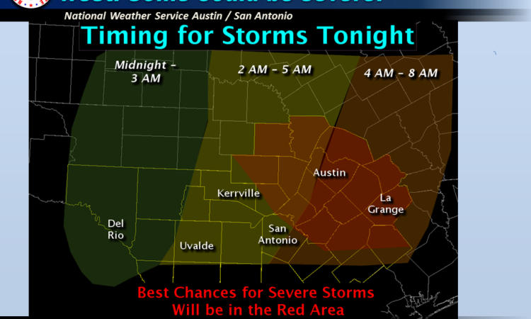
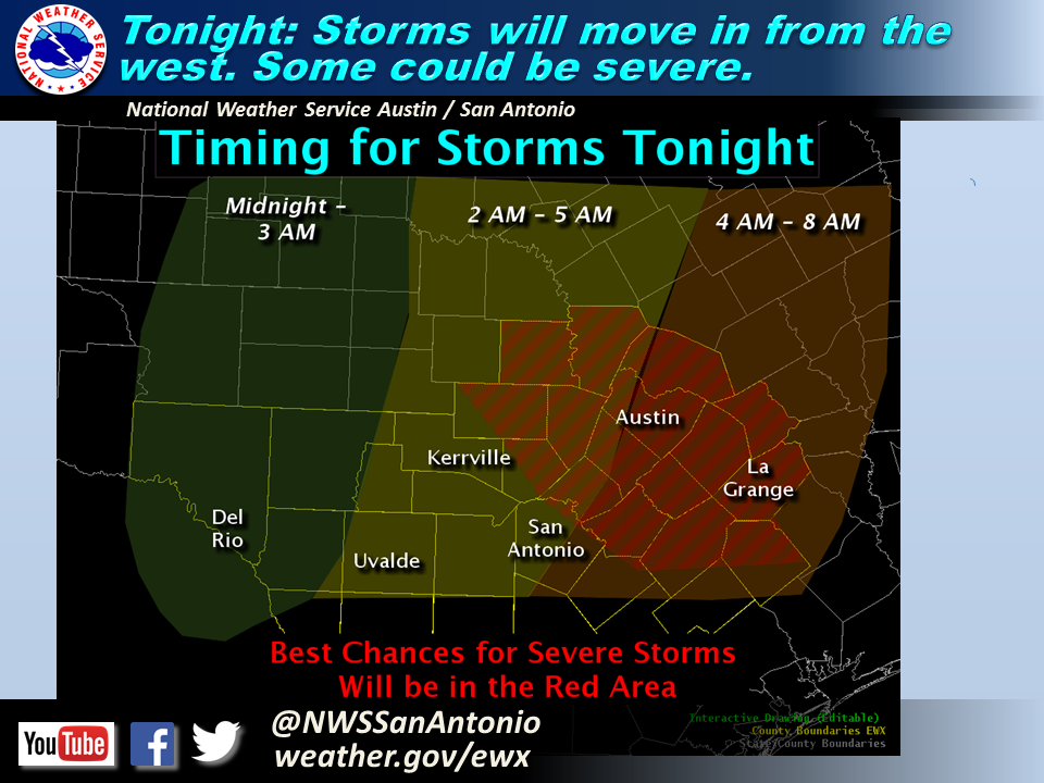
Timing & Area of Concern:
The greatest risk for storms will be along and north of a Del Rio to Uvalde to Victoria line.
12 AM – 3 AM: Rio Grande and Western Edwards Plateau
2 AM – 5 AM: Hill Country (West of I-35)
4 AM – 8 AM: Along and East of I-35
Threats & Impacts:
Hail: Quarter sized or greater.
Winds: Isolated wind gusts up to 60 mph.
Tornadoes: An isolated tornado is possible, mainly along and east of I-35 corridor.
Rainfall: 1/4-1/2 inch with isolated amounts up to 1 inch for the eastern Hill Country, Central Texas, and areas east of I-35. Less than 1/4 inch Rio Grande, Western Hill Country, and remainder of South Texas. Due to the speed of this system no significant flash flooding is expected.
Overview:
A potent upper level disturbance and Pacific cold front will generate a quick round of showers and storms late tonight through early Monday morning. The best chances for storms will be along and north of a Del Rio to Uvalde to Victoria line. Environmental conditions are favorable for some isolated storms to produce large hail in addition to damaging wind gusts across the region. In addition, a lower threat of an isolated tornado can’t be ruled out, mainly along and east of the I-35 corridor. The Storm Prediction Center has placed much of the area under a Slight Risk for severe storms tonight, but the area with the highest potential for severe weather is in red in the attached image.
Confidence:
Moderate
Additional Information Resources:
NWS Austin / San Antonio Webpage: https://www.weather.gov/sanantonio
Storm Prediction Center: https://www.spc.noaa.gov/
Online Severe Weather Reporting: https://www.srh.noaa.gov/StormReport/SubmitReport.php?site=EWX
Sincerely,
Nick Hampshire & Jon Zeitler
NWS Austin / San Antonio
Weather Forecast Office
Comments are closed.