Home

TTR News Center

Strong showers and thunderstorms possible late this afternoon and evening Bellville to Livingston northward.

No Comments Local News

IMG_0925

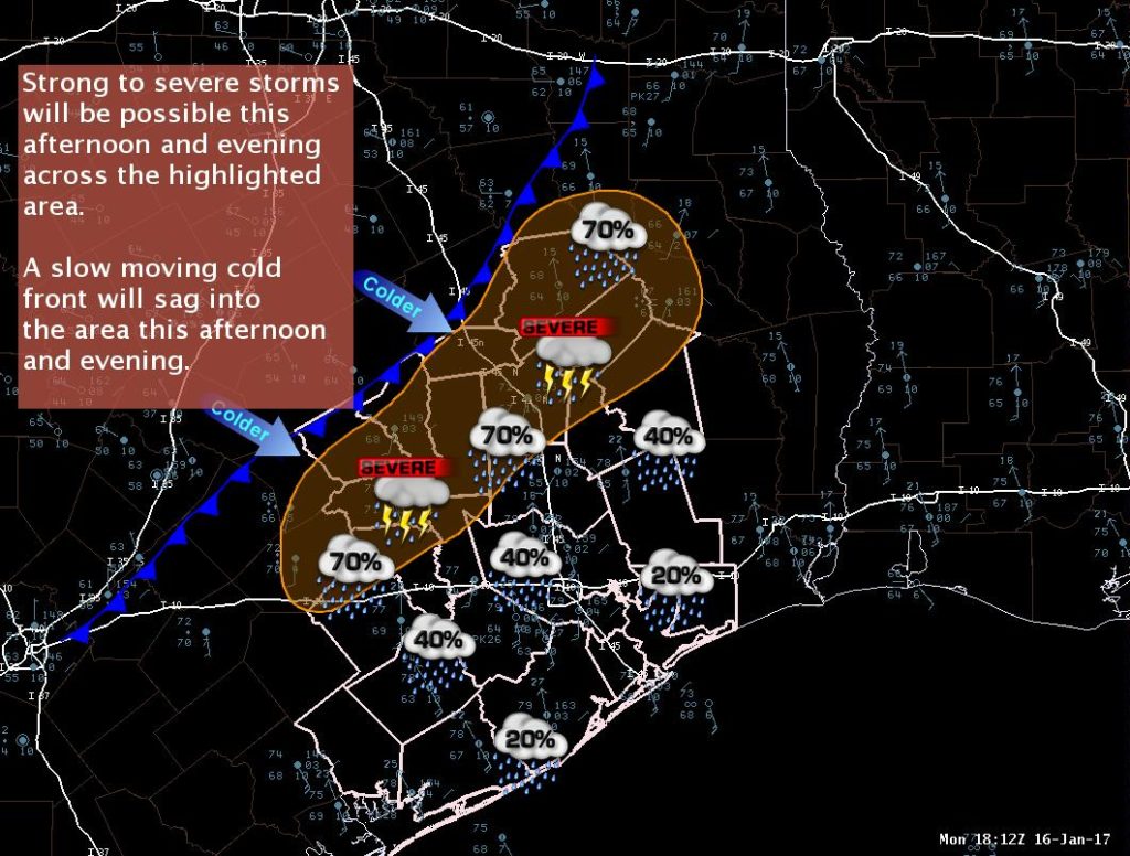
A slow moving cold front will become the focus for showers and thunderstorms this afternoon and likely continue into the evening hours.

The highlighted area has the greatest threat for isolated damaging winds/brief weak tornadoes/heavy rainfall. The ‘storms’ will be fairly slow moving and may not even be thunderstorms but still capable of damaging winds/weak tornadoes. The threat window should be between 3 pm and 9 pm.

The front will continue to sag southward and will likely remain a focus for widespread rain with showers and thunderstorms through Tuesday but with much lower threat for severe. Rainfall totals of 1/2 to 2 inches will be possible.

Kent Prochazka
NWS Houston/Galveston

Showers and Thunderstorms in the forecast. Here’s your TTR Weather Update from NWS Austin/San Antonio

No Comments Local News

image4
There are low chances of showers today and Saturday. Better chances for rain are expected over the weekend, especially Sunday into Monday. Stronger storms appear likely Sunday night into Monday morning. Periods of heavy rain and pockets of high wind could occur during this time-frame. Another round of possible heavy rain could occur Monday night into Tuesday as the front stalls across the region.

Rest Of Today

Mostly cloudy. Highs around 80. South winds 15 to 20 mph.

Tonight

Cloudy with a 20 percent chance of showers. Lows in the mid 60s. Southeast winds 10 to 15 mph.

Friday

Mostly cloudy with a 30 percent chance of showers. Highs in the upper 70s. Southeast winds 10 to 15 mph.

Friday Night

Mostly cloudy with a slight chance of showers and isolated thunderstorms. Lows in the mid 60s. Southeast winds 5 to 10 mph. Chance of rain 20 percent.

Saturday

Mostly cloudy with a slight chance of showers and isolated thunderstorms. Highs in the mid 70s. Southeast winds 10 to 15 mph. Chance of rain 20 percent.

Saturday Night

Mostly cloudy with a slight chance of showers and isolated thunderstorms. Lows in the lower 60s. Temperature steady or slowly rising after midnight. Chance of rain 20 percent.

Sunday And Sunday Night

Cloudy with a 50 percent chance of showers and thunderstorms. Highs in the mid 70s. Lows in the mid 60s.

Martin Luther King Jr Day

Cloudy with showers and thunderstorms likely. Highs in the lower 70s. Chance of rain 70 percent.

Monday Night
Cloudy with showers and thunderstorms likely. Lows in the mid 50s. Chance of rain 60 percent.

Luling Foundation to offer scholarships for graduating seniors in Caldwell, Gonzales, and Guadalupe Counties

No Comments Local News

The Luling Foundation offers Agriculture, Healthcare, and Trade/Vocational Scholarships Applications are now being accepted and are due by March 31, 2017. Graduating seniors residing in Caldwell, Gonzales, or Guadalupe County are eligible to apply.  Applications are available online www.lulingfoundation.org, through the high school counselor’s office, or at the county extension office.  For more information, contact The Luling Foundation at 830-875-2438 or lulingfoundation@sbcglobal.net.  

WIND ADVISORY REMAINS IN EFFECT UNTIL 6 PM CST THIS EVENING

No Comments Local News

A WIND ADVISORY REMAINS IN EFFECT UNTIL 6 PM CST THIS EVENING FOR BASTROP, CALDWELL, CALHOUN,  COLORADO, DE WITT, FAYETTE, GOLIAD, GONZALES, JACKSON, KARNES, LAVACA, VICTORIA, AND WHARTON COUNTIES.

* TIMING…FROM 10 AM UNTIL 6 PM.

  • WINDS…20 TO 30 MPH WITH GUSTS UP TO 40 MPH.
  • IMPACTS…DRIVING HIGH PROFILE VEHICLES MAY BE DIFFICULT ON EAST TO WEST ORIENTED ROADS. HIGH WINDS COULD DISPLACE  LOOSE ITEMS SUCH AS TRASH CANS AND LIGHT PATIO FURNITURE. LOOSE OBJECTS AND COULD RESULT IN MINOR PROPERTY DAMAGE  AND WILL MAKE OPEN WATERS OF AREA LAKES VERY CHOPPY AND DANGEROUS.

PRECAUTIONARY/PREPAREDNESS ACTIONS… A WIND ADVISORY MEANS THAT WINDS OF 26 TO 39 MPH ARE EXPECTED. WINDS THIS STRONG CAN MAKE DRIVING DIFFICULT…ESPECIALLY FOR HIGH PROFILE VEHICLES. USE EXTRA CAUTION.

TTR Weather Update for Victoria Crossroads including information for Victoria and Goliad Counties, Northern Coastal Bend, and Brush Country from NWS Corpus Christi.

No Comments Local News

…Wind Chill WARNING for Northern Coastal Bend, Victoria Crossroads and Brush Country 3 AM-9 AM Saturday…
…Wind Chill Advisory all of South Texas through Noon Saturday…
…Freeze Warning Tonight/Saturday AM…
…Freeze Watch Tomorrow Night…

No Winter Precipitation is Expected…

Briefing:

Cold temperatures and gusty winds will continue through the next 18-24 hours across South Texas. Temperatures this afternoon remain in the mid 30s with breezy north winds. Temperatures will begin to decrease this evening with winds continuing. This will lead to wind chill values between 15 and 25 degrees ongoing through the evening and into tonight. Wind chill values below 15 degrees are possible for portions of the area in the late night and early morning hours.
Freezing temperatures are also likely for all of South Texas tonight. Expect low temperatures in the mid and upper 20s for much of the area. Along the immediate coast, temperatures will drop into the lower 30s with a brief freeze possible. An additional round of freezing temperatures are expected Saturday Night into Sunday Morning.
Any light rain/drizzle should come to an end late this afternoon. No freezing precipitation is expected.
Small Craft Advisories continue for all marine areas. Marine wind speeds may temporarily decrease in intensity this afternoon, but quickly restrengthen this evening. A few gusts to gale force may occur tonight mainly over the offshore waters.South Texas Impacts:

  • Wind Chills: 
    • Values 15 to 25 degrees from this afternoon through Saturday morning.
    • Values 10 to 15 degrees between 3 and 9 am for Duval, Jim Wells, Live Oak, San Patricio, Bee, Refugio, Aransas, Goliad, Victoria, and Calhoun counties.
  • Freezing Temperatures:
    • Freeze Warning for all of South Texas tonight into Saturday morning.
    • Lows mid to upper 20s  (around 30 degrees for Laredo and along the coast).
    • Freeze Watch Saturday night into Sunday morning
    • Lows mid to upper 20s  (around 30 degrees for Laredo and along the coast).
  • Marine Conditions:
    • North winds restrengthening tonight to 25 to 30 knots.
    • Few gusts to gale force possible tonight.
    • Bays rough to occasionally very rough, especially this evening and overnight.
    • Seas 10 to 12 feet with locally higher seas possible.

1
2
3

Additional Information:
NWS Corpus Christi Webpage: www.weather.gov/crp/

Sincerely,
Penny Zabel
Forecaster
NWS Corpus Christi, TX