

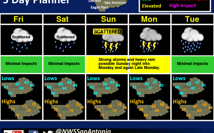
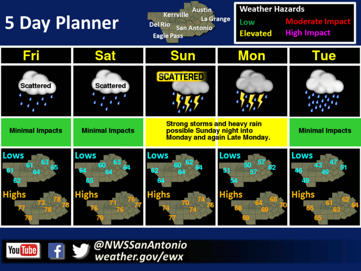
There are low chances of showers today and Saturday. Better chances for rain are expected over the weekend, especially Sunday into Monday. Stronger storms appear likely Sunday night into Monday morning. Periods of heavy rain and pockets of high wind could occur during this time-frame. Another round of possible heavy rain could occur Monday night into Tuesday as the front stalls across the region.
Mostly cloudy. Highs around 80. South winds 15 to 20 mph.
Cloudy with a 20 percent chance of showers. Lows in the mid 60s. Southeast winds 10 to 15 mph.
Mostly cloudy with a 30 percent chance of showers. Highs in the upper 70s. Southeast winds 10 to 15 mph.
Mostly cloudy with a slight chance of showers and isolated thunderstorms. Lows in the mid 60s. Southeast winds 5 to 10 mph. Chance of rain 20 percent.
Mostly cloudy with a slight chance of showers and isolated thunderstorms. Highs in the mid 70s. Southeast winds 10 to 15 mph. Chance of rain 20 percent.
Mostly cloudy with a slight chance of showers and isolated thunderstorms. Lows in the lower 60s. Temperature steady or slowly rising after midnight. Chance of rain 20 percent.
Cloudy with a 50 percent chance of showers and thunderstorms. Highs in the mid 70s. Lows in the mid 60s.
Cloudy with showers and thunderstorms likely. Highs in the lower 70s. Chance of rain 70 percent.
Comments are closed.