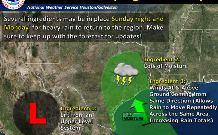
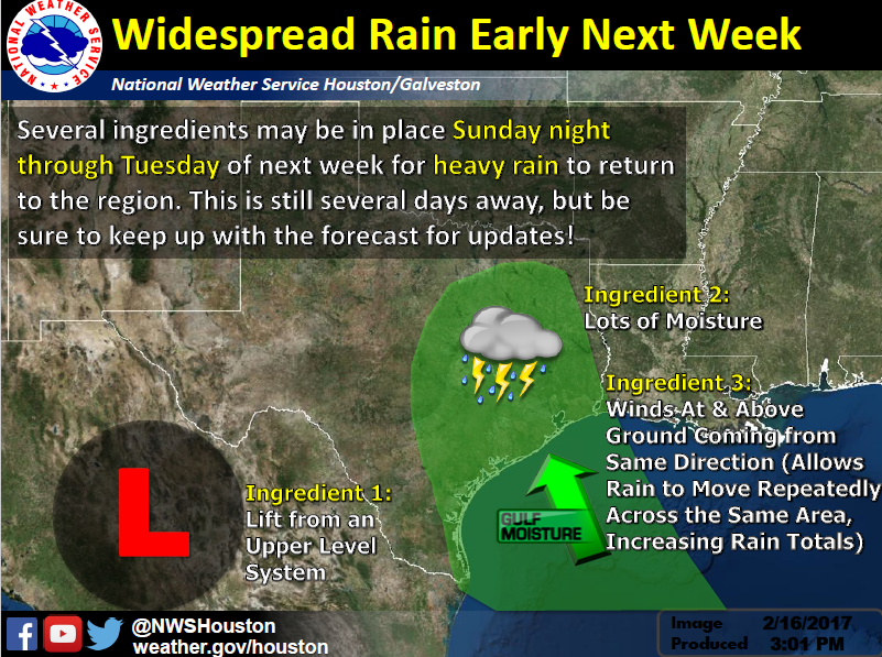
A strong storm system will approach the area Sunday night. This system will bring periods of showers and thunderstorms. Some of the rain could be heavy Sunday night into Monday morning.
Changes: Timing has changed. The system remains progressive and showers and thunderstorms could start as early as mid Sunday afternoon with a bulk of the rainfall occurring Sunday night into early Monday morning.
What: Heavy rain event with some potential for excessive rain that could lead to flooding.
Where: All of Southeast Texas but latest model consensus is focusing the heavier rain north and east of the Houston metro area.
When: The potential for heavy rain is greatest Sunday night into early Monday.
Primary Hazard: Heavy rain/flooding.
Secondary Hazard: Frequent lightning.
Confidence: Moderate. Timing differences between models and now some significant differences between the models on the geographic placement of the highest rainfall.
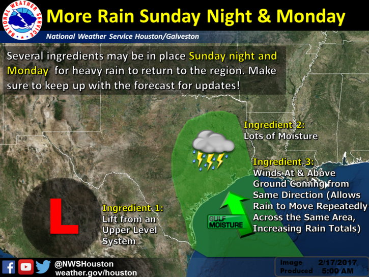
…Heavy Rainfall Event Possible Sunday Night through Monday…
Timing and Overview:
Atmospheric conditions are expected to become favorable for the development of a heavy rainfall event Sunday Night through Monday Afternoon primarily over the Coastal Bend and Victoria Crossroads regions of South Texas. South Texas Impacts:
Rainfall: Currently, rainfall amounts of 2 to 3 inches with isolated 4 to 6 inches are anticipated for the northern Coastal Bend and over the Victoria Crossroads for the period Sunday through Monday. Up to an inch of rainfall has fallen over portions of the northern Coastal Bend and Victoria Crossroads this Friday morning. The combination of additional rainfall Sunday and Monday may contribute to flash flooding over portions of the northern Coastal Bend and Victoria Crossroads.
The National Weather Service in Houston-Galveston continuing to monitor the potential for heavy rainfall and flooding Sunday night through Monday.
Bottom Line: We are still concerned for 1) Heavy rainfall and 2) small threat of strong/severe storms Monday.
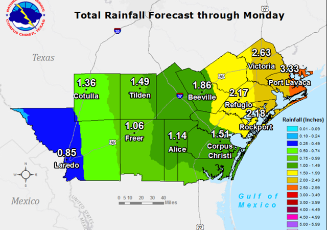
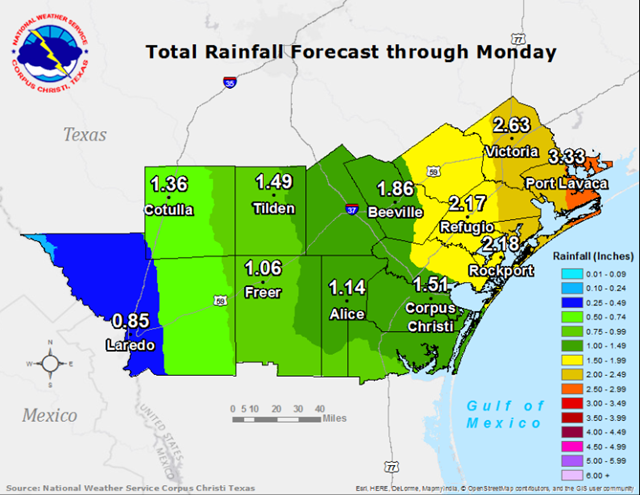
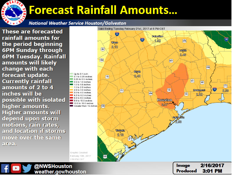
These are 2 day rainfall totals forecasted from 6PM Sunday to 6PM Tuesday. While the forecasted rainfall totals will likely change the next couple of days leading into the weekend, rainfall amounts of 2 to 4 inches of rain looks reasonable for much of the area. There will be isolated higher amounts but those will depend on details like storm motions and rainfall rates on smaller scales. Overall timing of the event looks on track.
Confidence:
Timing: medium to high confidence on Monday time frame for heavy rainfall and strong/severe storms.
Forecasted rainfall amounts: low to medium confidence on amounts. Medium to high confidence that it will rain.
Location: low to medium especially for isolated higher amounts of rainfall.
Impacts: medium confidence that if 4 inches or more of rain are realized there will be impacts to area rivers and bayous that could lead to flooding. Flash flooding may be possible.
0735 AM TSTM WND DMG 1 WNW EL CAMPO 29.20N 96.29W
02/14/2017 WHARTON TX TRAINED SPOTTER
TRAINED SPOTTER REPORTS POWER LINES DOWN ON W NORRIS AT
W LOOP IN EL CAMPO
0800 AM TORNADO 1 ENE WHARTON 29.32N 96.09W
02/14/2017 WHARTON TX NWS STORM SURVEY
DEBRIS AT BUSINESS 59 AT E BOLING HWY IN WHARTON. NWS
STORM SURVEY DETERMINED EF-0 DAMAGE MIXED WITH
MICROBURTS WINDS.
0813 AM TORNADO 6 SSW ROSENBERG 29.47N 95.83W
02/14/2017 FORT BEND TX TRAINED SPOTTER
TRAINED SPOTTER REPORTS BRIEF TORNADO TOUCHDOWN SSW OF
ROSENBURG
0820 AM TORNADO VAN VLECK 29.04N 95.88W
02/14/2017 MATAGORDA TX EMERGENCY MNGR
*** 6 INJ *** EF1 TORNADO. TREES DAMAGE… RVS FLIPPED
OVER… DAMAGE TO MULTIPLE HOMES IN VAN VLECK. DAMAGE
PATH ABOUT 1 MILE LONG. 6 MINOR INJURIES. NONE SERIOUS.
0825 AM TORNADO 5 WSW FIRST COLONY 29.55N 95.69W
02/14/2017 FORT BEND TX NWS STORM SURVEY
TREE… FENCE… STRUCTURAL DAMAGE IN TARA
SUBDIVISION… BRIDLEWOOD ESTATES AND GREATWOOD.
CONFIRMED EF2 TORNADO DAMAGE IN BRIDLEWOOD ESTATES.
0839 AM TORNADO STAFFORD 29.62N 95.56W
02/14/2017 FORT BEND TX EMERGENCY MNGR
SEVERAL ROOFS FROM HOMES AND BUSINESS BLOWN OFF FROM
MURPHY RD TO GREENBRIER RO IN STAFFORD.
0845 AM TORNADO SWEENY 29.05N 95.70W
02/14/2017 BRAZORIA TX 911 CALL CENTER
LARGE LIMBS AND MEDAL AWNING DOWN NEAR FM 524 IN
SWEENY. PICTURE OF TORNADO ON NWS HGX FACEBOOK PAGE.
0855 AM TSTM WND DMG SOUTHSIDE PLACE 29.71N 95.43W
02/14/2017 HARRIS TX PUBLIC
FENCES BLOWN DOWN AROUND 3700 BELLARE BLVD
0929 AM MARINE TSTM WIND 10 SW JONES CREEK 28.86N 95.57W
02/14/2017 M67 MPH BRAZORIA TX PORTS
WIND GUST AT SAN BERNARD NWR AT 58 KNOTS OR 67 MPH.
0950 AM TSTM WND DMG 16 ESE SAN LEON 29.43N 94.69W
02/14/2017 GALVESTON TX EMERGENCY MNGR
6 POWER POLES BLOWN DOWN ON THE BOLIVAR PENINSULA.
HELEN BLVD AT HIGHWAY 87