 ABC NewsBY: DANIEL MANZO, ABC NEWS
(NEW YORK) — After a turbulent week, the weather pattern this weekend is looking much quieter across the country.
However, a new storm is beginning to move through the Western U.S. and it will bring mountain snow and some rain to the major western cities.
Any rain across most of the Western U.S., and especially in Southern California, is very much welcomed at the moment but the rain looks like it might just miss Los Angeles where they have received less than half the average of their wet season rainfall to date.
Some mountain snow could also make for treacherous travel, especially in the mountains passes in the Sierra.
By Monday, some of this activity will move into the Central U.S. and become the next organized system that will bring impactful weather to the eastern half of the nation.
After receiving their fourth largest snowstorm on record earlier this week, it appears another round of snow is headed for the Denver metro area by Monday.
Additionally, the developing storm will spark the next round of severe weather with strong storms developing later Monday across Oklahoma and Texas. The risk includes the threat of damaging winds.
By Tuesday and Wednesday, the threat for rain and strong storms will move further south and east.
There will likely be another severe weather threat across portions of the Gulf states in this time frame.
The result of this pattern is, locally, over a foot of snow in some of the northern Rockies and Cascades through Monday.
Several inches of snow will be possible in the urban corridor of Colorado as well on Monday and, locally, 2 to 3 inches of rain is possible through Monday in parts of the central Plains and Midwest.
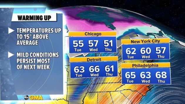
The other big news is that it is officially spring this morning and spring-like temperatures will surge into the Midwest and Northeast over the next few days.
Temperatures will likely be 10 to 15 degrees above average in the coming days across this region.
Copyright © 2021, ABC Audio. All rights reserved.


Comments are closed.