 ABC NewsBY: BRITTANY BORER, ABC NEWS
(NEW YORK) — Heavy snow is expected for the Cascades and Rockies today with rounds of rain for the coast and this pattern is forecast to continue for the next couple of days.
A foot of snow is likely for parts of the Northern Rockies while multiple feet of snow are expected over parts of the northern Cascades with heavy rain of up to 4 inches or more is expected in the Pacific Northwest coast through Thursday.
A weak disturbance will move across the Midwest bringing light to moderate snow this afternoon and evening.
Isolated light snow showers are possible from parts of the Northeast and Central Appalachians today and snow will begin in Chicago this evening and last overnight.
Snow will be falling throughout the Monday morning commute for Pittsburgh and Cleveland with rain enveloping the Tennessee Valley.
Some pockets of light freeing rain may even develop across parts of the Central Appalachians and may begin in New York as snow in the early afternoon but end as rain by Monday evening.
Rain showers will spread across the Middle and Lower Mississippi Valley, the Tennessee Valley, Southeast and Mid-Atlantic regions throughout the day.
Some areas of scattered to isolated thunderstorms may develop along the Carolina and Southeast coasts on Monday night and snow will still be falling in parts of New England by Monday evening before pulling the moisture offshore overnight.
An estimated 2 to 4 inches of snow is likely for much of the Upper Midwest with locally higher amounts possible in Iowa today.
The Central Appalachians and interior Northeast will also see a general area of 2-4 inches while locally heavier amounts are expected for areas downwind of the Lower Great Lakes tonight into tomorrow.
The good news is that most of the country is looking at a much quieter weather pattern this week with only the Pacific Northwest, however, being the exception as they should see rounds of rain and snow.
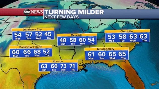
Additionally, temperatures will finally get back to near seasonable levels across the central US this week.
Dallas is forecast to reach 60 degrees on Sunday, which is the first time temperatures will be that mild since Feb. 8, almost two weeks ago, and will be just short of their average high by 2 degrees.
Charlotte will be at 58 degrees on Tuesday which is the mildest since Feb. 10 and will be 2 degrees above average.
It should get up to 70 degrees or higher at San Diego International Airport on Sunday which will be the first time since Feb. 1 and this will be 5 degrees above average for them.
Copyright © 2021, ABC Audio. All rights reserved.


Comments are closed.