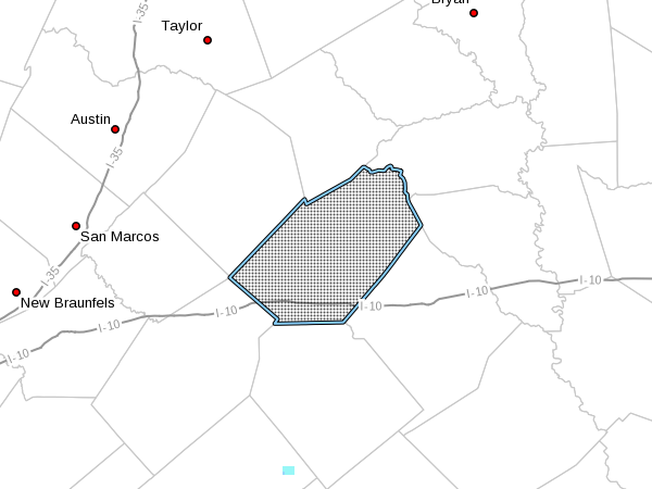

…TROPICAL STORM WATCH IN EFFECT…
A Tropical Storm Watch means Tropical storm wind conditions are
possible somewhere within this area and within the next 48 hours
Peak Wind Forecast: 30-40 mph with gusts to 50 mph
CURRENT THREAT TO LIFE AND PROPERTY: Moderate
Dangerous wind is possible. Failure to adequately shelter
may result in injury.
POTENTIAL IMPACTS: Significant
Scattered power and communications outages, but more
prevalent in areas with above ground lines.
FLOODING RAIN
Peak Rainfall Amounts: 6-10 inches, with locally higher
amounts
CURRENT THREAT TO LIFE AND PROPERTY: Elevated
Localized flooding is possible. If flood related watches
and warnings are issued, heed recommended actions.
POTENTIAL IMPACTS: Limited
Flood waters can enter a few structures, especially in
usually vulnerable spots. A few places where rapid ponding
of water occurs at underpasses, low-lying spots, and poor
drainage areas. Several storm drains and retention ponds
become near-full and begin to overflow. Some brief road and
bridge closures.
TORNADO
Situation is favorable for isolated tornadoes
CURRENT THREAT TO LIFE AND PROPERTY: None
Ensure readiness for the next tropical tornado event.
POTENTIAL IMPACTS: Little to None
…TROPICAL STORM WATCH IN EFFECT…
A Tropical Storm Watch means Tropical storm wind conditions are
possible somewhere within this area and within the next 48 hours
La Grange
WIND
Peak Wind Forecast: 25-35 mph with gusts to 50 mph
CURRENT THREAT TO LIFE AND PROPERTY: Moderate
Dangerous wind is possible. Failure to adequately shelter
may result in injury.
POTENTIAL IMPACTS: Significant
Scattered power and communications outages, but more
prevalent in areas with above ground lines.
FLOODING RAIN
Peak Rainfall Amounts: Additional 4-8 inches, with locally
higher amounts
CURRENT THREAT TO LIFE AND PROPERTY: Elevated
Localized flooding is possible. If flood related watches
and warnings are issued, heed recommended actions.
POTENTIAL IMPACTS: Limited
Flood waters can enter a few structures, especially in
usually vulnerable spots. A few places where rapid ponding
of water occurs at underpasses, low-lying spots, and poor
drainage areas. Several storm drains and retention ponds
become near-full and begin to overflow. Some brief road and
bridge closures.
TORNADO
Situation is unfavorable for tornadoes
CURRENT THREAT TO LIFE AND PROPERTY: None
Ensure readiness for the next tropical tornado event.
POTENTIAL IMPACTS: Little to None
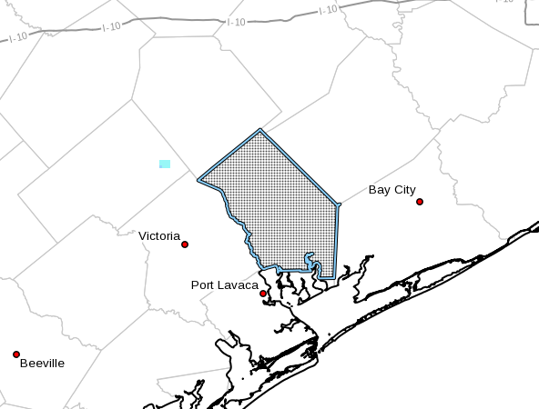
…HURRICANE WATCH IN EFFECT…
…STORM SURGE WATCH IN EFFECT…
A Hurricane Watch means Hurricane wind conditions are possible
somewhere within this area and within the next 48 hours
A Storm Surge Watch means life-threatening inundation levels are
possible somewhere within this area and within the next 48 hours
Window for Tropical Storm force winds: Friday morning until
Saturday afternoon
CURRENT THREAT TO LIFE AND PROPERTY: Moderate
Dangerous wind is possible. Failure to adequately shelter
may result in injury.
POTENTIAL IMPACTS: Significant
Scattered power and communications outages, but more
prevalent in areas with above ground lines.
STORM SURGE
Window of concern: Begins Friday morning
CURRENT THREAT TO LIFE AND PROPERTY: Moderate
Life-threatening inundation is possible. Failure to heed
evacuation orders may result in serious injury or loss of
life. Leave if evacuation orders are given for your area.
Consider voluntary evacuation if recommended. Poor
decisions may needlessly risk lives.
POTENTIAL IMPACTS: Significant
Moderate damage to marinas, docks, boardwalks, and piers.
Several small craft broken away from moorings, especially
in unprotected anchorages.
FLOODING RAIN
Peak Rainfall Amounts: 8-12 inches, with locally higher
amounts
CURRENT THREAT TO LIFE AND PROPERTY: Elevated
Localized flooding is possible. If flood related watches
and warnings are issued, heed recommended actions.
POTENTIAL IMPACTS: Limited
Flood waters can enter a few structures, especially in
usually vulnerable spots. A few places where rapid ponding
of water occurs at underpasses, low-lying spots, and poor
drainage areas. Several storm drains and retention ponds
become near-full and begin to overflow. Some brief road and
bridge closures.
TORNADO
Situation is favorable for isolated tornadoes
CURRENT THREAT TO LIFE AND PROPERTY: None
Ensure readiness for the next tropical tornado event.
POTENTIAL IMPACTS: Little to None
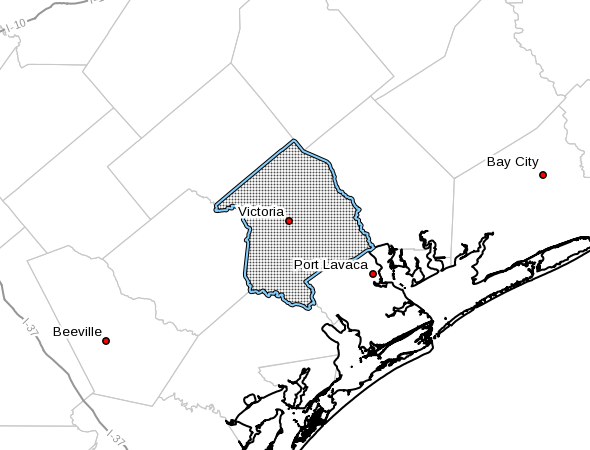
…HURRICANE WATCH IN EFFECT…
A Hurricane Watch means Hurricane wind conditions are possible
somewhere within this area and within the next 48 hours
Bloomington
WIND
Window for Tropical Storm force winds: early Friday morning
until early Sunday morning
CURRENT THREAT TO LIFE AND PROPERTY: Moderate
Dangerous wind is possible. Failure to adequately shelter
may result in injury.
POTENTIAL IMPACTS: Significant
Scattered power and communications outages, but more
prevalent in areas with above ground lines.
FLOODING RAIN
Peak Rainfall Amounts: 6-10 inches, with locally higher
amounts
CURRENT THREAT TO LIFE AND PROPERTY: Elevated
Localized flooding is possible. If flood related watches
and warnings are issued, heed recommended actions.
POTENTIAL IMPACTS: Limited
Flood waters can enter a few structures, especially in
usually vulnerable spots. A few places where rapid ponding
of water occurs at underpasses, low-lying spots, and poor
drainage areas. Several storm drains and retention ponds
become near-full and begin to overflow. Some brief road and
bridge closures.
TORNADO
Situation is unfavorable for tornadoes
CURRENT THREAT TO LIFE AND PROPERTY: None
Ensure readiness for the next tropical tornado event.
POTENTIAL IMPACTS: Little to None
Little to no potential impacts from tornadoes.
FOR MORE INFORMATION: