Home

TTR News Center

TTR Weather Update

No Comments Local News

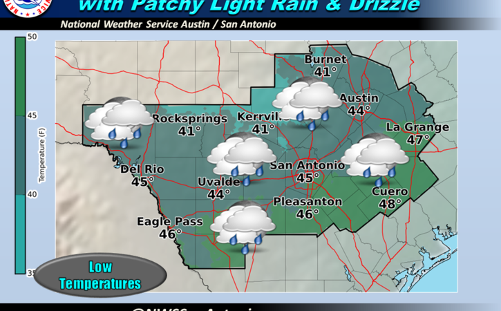
Through this evening, patchy sprinkles and light rain will continue across portions of South Central Texas, particularly along the Interstate 35 and 37 corridors south of San Marcos. Rainfall amounts should range from a trace to a few hundredths of an inch.

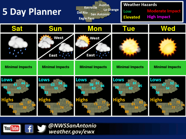
Tonight, moisture will continue to overrun a shallow cold air mass and will produce intermittent light rain and patchy drizzle. Rainfall amounts tonight should be only a trace or a few hundredths of an inch. Look for northeast winds of 5 to 15 mph and minimum temperatures in the 40s. Cloudy skies and isolated light rain showers will keep temperatures well below normal on Saturday. A warming trend begins Saturday night leading to well above normal temperatures on Sunday and Monday with isolated light rain showers across areas generally east of Highway 281. Near record high temperatures are expected on Tuesday under mostly sunny skies. A Pacific front drops temperatures a little for Wednesday, though they remain well above normal.

image4
Now, here’s your Forecast from the TTR WeatherCenter –

Tonight: Cloudy with a 20 percent chance of rain. Lows in the upper 40s. Northeast winds 10 to 15 mph.

Saturday: Cloudy with a 20 percent chance of showers. Highs in the lower 60s. East winds 5 to 10 mph.

Saturday Night: Warmer. Cloudy with a 20 percent chance of showers. Near steady temperature around 60. Southeast winds 5 to 10 mph.

Sunday: Warmer. Cloudy with a 20 percent chance of showers. Highs in the mid 70s. South winds 10 to 15 mph.

Sunday Night: Mostly cloudy with a 20 percent chance of showers. Lows in the mid 60s. South winds 10 to 15 mph.

Monday And Monday Night: Mostly cloudy with a 20 percent chance of showers. Highs in the upper 70s. Lows in the mid 60s.

Tuesday: Partly cloudy. Highs around 80.

Tuesday Night Through Wednesday Night: Mostly clear. Lows in the mid 50s. Highs in the mid 70s.

Thursday And Thursday Night: Partly cloudy. Highs in the lower 70s. Lows around 50.

Friday: Partly cloudy. Highs in the mid 60s

Have a great weekend.

Special Weather Statement for Calhoun, TX, Goliad, TX, Victoria, TX

No Comments Local News

Special Weather Statement
National Weather Service Corpus Christi TX
332 PM CST Wed Feb 1 2017

TXZ229>234-239>247-020500-
La Salle-McMullen-Live Oak-Bee-Goliad-Victoria-Webb-Duval-
Jim Wells-Kleberg-Nueces-San Patricio-Aransas-Refugio-Calhoun-
Including the cities of Cotulla, Calliham, Cross, Loma Alta,
Tilden, George West, Three Rivers, Beeville, Goliad, Victoria,
Laredo, Freer, Benavides, San Diego, Alice, Orange Grove,
Kingsville, Corpus Christi, Portland, Ingleside, Aransas Pass,
Sinton, Mathis, Rockport, Refugio, Woodsboro, and Port Lavaca
332 PM CST Wed Feb 1 2017

…Areas of Dense Fog Expected Tonight…

Light winds due to an approaching frontal boundary will trap
higher moisture over South Texas tonight and into Thursday
morning, with good radiational cooling expected. As a result,
areas of dense fog will likely be over much of South Texas by
sunrise Thursday.

Depending on the frontal location early Thursday morning, areas
south of the frontal boundary will likely experience dense fog at
times. North of the front, the fog has a lower potential to become
dense, although with the slow-moving boundary fog will likely
still be present behind it.

If widespread dense fog develops later tonight or the confidence
in widespread dense fog become high, a Dense Fog Advisory will be
issued for the appropriate areas of South Texas.

Overnight and morning commuters should prepare for the likelihood
of requiring extra time to reach your destinations. When driving
in areas of reduced visibility, slow down and use your low beam
headlights.

Stay tuned to NOAA Weather Radio, commercial radio or television
for the latest updates and possible advisories.

TTR Weekend Weather Forecast

No Comments Local News

There will be a low chance for light rain showers across most areas Friday night into Saturday, but rainfall amounts will remain low. Below normal temperatures are expected across most areas on Friday and Saturday due to increased cloudiness and light rain. Otherwise, fair weather and near normal temperatures are expected for the remainder of the weekend into next week.

image4

Now, here’s your TTR Weekend Weather Forecast from NWS Austin – San Antonio –

Tonight: Cloudy with a 20 percent chance of showers. Lows in the lower 40s. North winds 5 to 10 mph.

Saturday: Cloudy with a 30 percent chance of showers in the morning, then partly cloudy in the afternoon. Highs in the upper 50s. Northwest winds 10 to 15 mph.

Saturday Night: Mostly clear. Lows in the mid 30s. Northwest winds 5 to 10 mph.

Sunday: Sunny. Highs in the mid 60s. Northwest winds 10 to 15 mph.

Sunday Night: Clear. Lows in the upper 30s. Northwest winds 5 to 10 mph.

DENSE FOG ADVISORY IN EFFECT FOR MOST OF SOUTH TEXAS

No Comments Local News

URGENT – WEATHER MESSAGE

NATIONAL WEATHER SERVICE CORPUS CHRISTI TX
758 PM CST FRI JAN 20 2017

…DENSE FOG ADVISORY IN EFFECT FOR MOST OF SOUTH TEXAS…

.AREAS OF DENSE FOG HAVE ALREADY DEVELOPED ACROSS PORTIONS OF COASTAL SOUTH TEXAS…AND ARE EXPECTED TO DEVELOP ACROSS INLAND AREAS OF SOUTH TEXAS THROUGH THIS EVENING AND ESPECIALLY OVERNIGHT.

TXZ231>234-240>247-211200-
/O.NEW.KCRP.FG.Y.0003.170121T0158Z-170121T1200Z/
LIVE OAK-BEE-GOLIAD-VICTORIA-DUVAL-JIM WELLS-KLEBERG-NUECES-
SAN PATRICIO-ARANSAS-REFUGIO-CALHOUN-
INCLUDING THE CITIES OF GEORGE WEST, THREE RIVERS, BEEVILLE,
GOLIAD, VICTORIA, FREER, BENAVIDES, SAN DIEGO, ALICE,
ORANGE GROVE, KINGSVILLE, CORPUS CHRISTI, PORTLAND, INGLESIDE,
ARANSAS PASS, SINTON, MATHIS, ROCKPORT, REFUGIO, WOODSBORO,
AND PORT LAVACA
758 PM CST FRI JAN 20 2017

…DENSE FOG ADVISORY IN EFFECT UNTIL 6 AM CST SATURDAY…

THE NATIONAL WEATHER SERVICE IN CORPUS CHRISTI HAS ISSUED A DENSE FOG ADVISORY, WHICH IS IN EFFECT UNTIL 6 AM CST SATURDAY.

* VISIBILITY…LOWERING TO 1/4 OR LESS AT TIMES.

* IMPACTS…AREAS OF DENSE FOG WILL RESULT IN HAZARDS DRIVING
CONDITIONS.

PRECAUTIONARY/PREPAREDNESS ACTIONS…

A DENSE FOG ADVISORY MEANS VISIBILITIES WILL FREQUENTLY BE
REDUCED TO LESS THAN ONE QUARTER MILE. IF DRIVING…SLOW DOWN… USE LOW-BEAM HEADLIGHTS…AND LEAVE PLENTY OF DISTANCE AHEAD OF
YOU.

&&