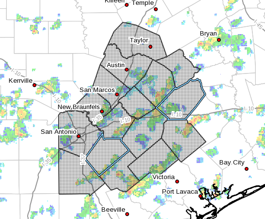
Hurricane Harvey Local Statement Advisory Number 18
National Weather Service Austin/San Antonio TX AL092017
431 PM CDT Thu Aug 24 2017
This product covers SOUTH CENTRAL TEXAS
Hurricane Harvey expected to bring a life-threatening heavy rainfall
event across South Central Texas
NEW INFORMATION
- CHANGES TO WATCHES AND WARNINGS:
- None
-
CURRENT WATCHES AND WARNINGS:
- A Tropical Storm Warning is in effect for Atascosa, Bastrop,
Bexar, Caldwell, Fayette, Gonzales, Guadalupe, Lavaca, and
Wilson -
A Hurricane Warning is in effect for De Witt and Karnes
-
STORM INFORMATION:
- About 450 miles south-southeast of Austin TX or about 370 miles
southeast of Cuero TX - 24.7N 93.9W
- Storm Intensity 85 mph
- Movement North-northwest or 330 degrees at 10 mph
SITUATION OVERVIEW
Harvey continues to strengthen and is now a Category One Hurricane.
Harvey is still moving slowly northwestward in the Gulf of Mexico. This
northwestward movement is expected to continue and Harvey should
approach the Texas coast late Friday into Saturday. Confidence
continues to increase for tropical storm winds and a significant heavy
rainfall event across South Central Texas beginning Friday afternoon
and continuing through Tuesday. Flash flooding and river flooding
continue to be the main concerns, mainly within the Tropical Storm
Warning and Flash Flood Watch areas.
Hurricane Harvey will produce a life-threatening heavy rainfall event.
Storm total rainfall amounts from Friday through Tuesday could be in
the 10 to 20 inch range along and east of Interstate 35 with isolated
totals in excess of 25 inches possible over areas south of Interstate
10 as Harvey is expected to stall over the area. Devastating mainstem
river flooding is possible east of Interstate 35 and south of
Interstate 10.
Additionally, hurricane force winds of 70 to 80 mph will be possible
for the counties within the Hurricane Warning, while 40 to 50 mph
winds with some gusts to 60 mph will be possible for areas within the
Tropical Storm Warning. The timing of these winds look to arrive Friday
night through Saturday morning. There is a low risk of brief tornadoes
east of Interstate 35 and south of Interstate 10 Friday evening into
the weekend associated with tropical rain bands.
POTENTIAL IMPACTS
- FLOODING RAIN:
Protect against life-threatening rainfall flooding having possible
devastating impacts across areas east of Interstate 35 and south of
Interstate 10. Potential impacts include: - Extreme rainfall flooding may prompt numerous evacuations and
rescues. - Rivers and tributaries may overwhelmingly overflow their banks
in many places with deep moving water. Small streams, creeks,
canals, arroyos, and ditches may become raging rivers. In
mountain areas, deadly runoff may rage down valleys while
increasing susceptibility to rockslides and mudslides. Flood
control systems and barriers may become stressed. - Flood waters can enter numerous structures within multiple
communities, some structures becoming uninhabitable or washed
away. Numerous places where flood waters may cover escape
routes. Streets and parking lots become rivers of raging water
with underpasses submerged. Driving conditions become very
dangerous. Numerous road and bridge closures with some weakened
or washed out.
Protect against life-threatening rainfall flooding having possible
limited to extensive impacts across areas along and east of the
Interstate 35 Corridor.
- WIND:
Protect against life-threatening wind having possible devastating
impacts across areas in the Tropical Storm and Hurricane Warnings
mainly east of Interstate 35. Potential impacts in this area include: - Structural damage to sturdy buildings, some with complete roof
and wall failures. Complete destruction of mobile homes. Damage
greatly accentuated by large airborne projectiles. Locations
may be uninhabitable for weeks or months. - Numerous large trees snapped or uprooted along with fences and
roadway signs blown over. - Many roads impassable from large debris, and more within urban
or heavily wooded places. Many bridges, causeways, and access
routes impassable. - Widespread power and communications outages.
Also, protect against life-threatening wind having possible limited
to extensive impacts across areas along and east of the Interstate 35
Corridor.
- TORNADOES:
Protect against a tornado event having possible limited impacts across
areas within the Tropical Storm and Hurricane Warnings. Potential
impacts include: - The occurrence of isolated tornadoes can hinder the execution
of emergency plans during tropical events. - A few places may experience tornado damage, along with power
and communications disruptions. - Locations could realize roofs peeled off buildings, chimneys
toppled, mobile homes pushed off foundations or overturned,
large tree tops and branches snapped off, shallow-rooted trees
knocked over, moving vehicles blown off roads, and small boats
pulled from moorings.
Elsewhere across SOUTH CENTRAL TEXAS, little to no impact is
anticipated.
PRECAUTIONARY/PREPAREDNESS ACTIONS
- OTHER PREPAREDNESS INFORMATION:
|Now is the time to bring to completion all preparations to protect
life and property in accordance with your emergency plan.
Check-in with your emergency points of contact among family, friends,
and workmates. Inform them of your status and well-being. Let them know
how you intend to ride out the storm and when you plan to check-in
again.
In emergencies it is best to remain calm. Stay informed and focused
on the situation at hand. Exercise patience with those you encounter.
Be a Good Samaritan and helpful to others.
If relocating to a nearby shelter or to the home of a family member
or friend, drive with extra caution, especially on secondary roads.
Remember, many bridges and causeways will be closed once higher winds
arrive. Also, if you encounter water covering the road, seek an
alternate route. Always obey official road signs for closures and
detours.
Closely monitor NOAA Weather radio or other local news outlets for
official storm information. Be ready to adapt to possible changes to
the forecast.
- ADDITIONAL SOURCES OF INFORMATION:
- For information on appropriate preparations see ready.gov
- For information on creating an emergency plan see getagameplan.org
- For additional disaster preparedness information see redcross.org
NEXT UPDATE
The next local statement will be issued by the National Weather
Service in Austin/San Antonio TX around 11 PM CDT, or sooner if
conditions warrant.


Comments are closed.